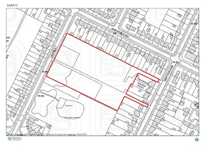
- 3ha
- 46 homes to 2037
- From 2025-2026
Policy 23 of the Local Plan identifies that the following infrastructure and services should be provided through the new development:
Housing
- 15% of homes will be for affordable housing, 25% of these will be First Homes for first time buyers
- All market housing should be designed as accessible housing for older people
Green/blue infrastructure
- Financial contribution to improve the adjoining open space, including facilities for children and young people
- 10% biodiversity net gain
- 5 new trees per home
Social and community facilities
- Financial contribution towards primary healthcare (improving doctor’s surgery) in the area
- Financial contribution towards improving Bassetlaw Hospital
Transport infrastructure
- Safe access for vehicles onto Leafield
- Pedestrian and cycle links between Leafield and West Furlong
- Highways demand management measures
- Financial contribution to improve:
- A620 Babworth Road / B6420 Mansfield Road / A620 Straight Mile / Sutton Lane junction;
- Ordsall Road/A620 Babworth Road junction
- London Road / Whinney Moor Lane / Bracken Lane junction
- London Road / Whitehouses Road junction
Masterplanning
- The site promoters should prepare a masterplan and a delivery strategy; including details of the infrastructure to be provided by the development and when it will be delivered
Last Updated on Wednesday, May 8, 2024