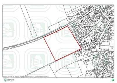
- 9ha
- 75 homes to 2037
- From 2025-2026
Policy 28 of the Local Plan identifies that the following infrastructure and services should be provided through the new development:
Housing
- 25% of homes will be for affordable housing, 25% of these will be First Homes for first time buyers
- All market housing should be designed as accessible housing for older people
Green/blue infrastructure
- Financial contribution to improve open space in the locality
- 10% biodiversity net gain
- 5 new trees per home
Social and community facilities
- Financial contribution towards delivering primary and secondary school facilities in the area
- Financial contribution towards primary healthcare (improving doctor’s surgery) in the area
- Financial contribution towards improving Bassetlaw Hospital
Transport infrastructure
- Safe access for vehicles, pedestrians and cyclists onto Ollerton Road, capable of accommodating public transport
- Financial contribution to improve public transport facilities in the locality
- Pedestrian footway connecting the existing footway on Ollerton Road with The Pastures
- Pedestrian/cyclepath connection from the southern boundary to Long Lane and a financial contribution to improve its surface to Tuxford centre
- Connections to the public rights of way network adjoining the site
Masterplanning
- The site promoters should prepare a masterplan and a delivery strategy; including details of the infrastructure to be provided by the development and when it will be delivered
Last Updated on Wednesday, May 8, 2024