Contents
- Introduction
- Housing in Worksop
- Employment in Worksop
- Infrastructure and the Local Plan
- Infrastructure Funding Gap
- Peaks Hill Farm Infrastructure Breakdown
- Flooding
Introduction
What is the local plan?
The Local Plan sets out how many new homes and businesses Bassetlaw needs in the future, where they should go, and what services like schools, hospitals, doctors, shops and transport will be needed. The Plan lasts for 14 years.
The Local Plan also sets out where other new buildings are allowed to be built in Bassetlaw over this period, and which places like open spaces and wildlife areas should be protected from development.
The Government requires all Councils with responsibility for planning, like Bassetlaw, to have a Local Plan. Without a Local Plan in place, it is much harder for Councils to control where new building can take place and to make sure the right type and amount of services will be provided.
The Independent Planning Inspectorate wrote to Bassetlaw District Council on the 21st February 2024 to confirm that following examination, it had found the Local Plan ‘sound’ as long as some changes recommended by the Planning Inspectors (called main modifications) are made. This is a normal part of the Plan process. The Government website states that: “In most cases the report will recommend some changes that are necessary to allow the plan to be adopted. These are known as ‘main modifications’.”
You can learn more about the Main Modifications for the Bassetlaw Local Plan by reading the Technical Summary (page 4) of the Inspectors’ report.
But what does being ‘sound’ mean?
The law requires all Local Plans to be examined by the Independent Planning Inspectorate to determine if they are ‘sound’ or not. The Planning Inspectors have to check that the Council has prepared the Local Plan in accordance with legal and procedural requirements, and that it meets the four tests of soundness:
- Positively Prepared – the plan should be based on strategy that meets development and infrastructure requirements, and will achieve sustainable development;
- Justified – the plan should be the most appropriate strategy when considered against reasonable alternatives;
- Effective – the plan should be deliverable;
- Consistent with national policy – the plan should enable the delivery of sustainable development in line with National Planning Policy.
By finding the Local Plan ‘sound’, the Inspectors agree that with their changes the Council has met all these tests and that the Plan sets out appropriate, sustainable and deliverable development, supported by new infrastructure across Bassetlaw over the next 14 years.
Housing in Worksop
The Bassetlaw Local Plan calls for a total of 2,560 homes to be built in Worksop by 2038. However, because numerous new homes have either already been built, allocated through other routes such as Neighbourhood Plans or have planning permission, the Local Plan only allocates 910 new homes in Worksop.
This contributes to the total number of houses to be built across Bassetlaw. The Local Plan calls for 11,195 homes to be built by 2038, which will support the creation of 9,699 new jobs and provide more specialist homes, such as: homes for first time buyers; new affordable housing; wheelchair and accessible housing and housing for older people.
The infographic here illustrates the housing need for Worksop.

Employment in Worksop
5 hectares* at Peaks Hill Farm for businesses;
9 employment sites protected for businesses to operate and grow;
Support for town centre regeneration.
*1 hectare is equivalent to roughly one and a half football fields.
Infrastructure and the Local Plan
The Local Plan sets out areas of land where new building or development can take place. This is usually for new housing, new businesses or a mixture of both.
The Local Plan has to take into account the impact that this new development will have on the existing services or infrastructure that people use. For example, a new housing development might mean more cars on the road, more children needing to go to school or more people needing to register at the doctors.
The Local Plan addresses these issues by identifying what new infrastructure will be needed to support the people who will be living or working in these new areas. The Local Plan will then require any developers wishing to build in these areas to either deliver these measures themselves or provide the money for them to be delivered. This could include things like new bus routes, parks, road improvements such as roundabouts and new junctions, new health care facilities and new schools.
There are some things that the Local Plan can’t ask for money for. New development in the Plan cannot address existing problems with services. For example, if there are parking problems outside a school at drop off time, developers can’t pay to address that problem. In addition, developers’ money cannot be used to provide new staff, like nurses or teachers.
The Infrastructure Funding Gap, what is CIL and S106, and why does it matter?
You may have seen or heard about something called the Infrastructure Funding Gap as well as phrases like CIL and S106. But what are they, and why do they matter?
Infrastructure is usually funded through money provided by developers to help with the impact of new building. Sometimes the Council will ask for money through Section 106 Agreements (S106). These are payments tied to specific areas, meaning the money has to be spent in the local area. The Council can also use Community Infrastructure Levy (CIL) payments to fund infrastructure improvements. These are raised from developers and can be spent across the District. Other sources of funding could include money from Government or the new East Midlands Mayor.
The Local Plan calculates how much money will be needed to deliver infrastructure development in Bassetlaw up to 2038. It also shows where the money will come from. The Infrastructure Funding Gap defines the difference between how much money is needed, and the amount that developers will pay through Section 106 agreements.
Having a funding gap may sound like a bad thing, but without it, we would not be able to raise any money through CIL. By showing this funding gap, the Council is able to demonstrate the need for CIL monies and use them to support the delivery of infrastructure in the Local Plan.
Infrastructure funding gap for Bassetlaw
Let's break it down...
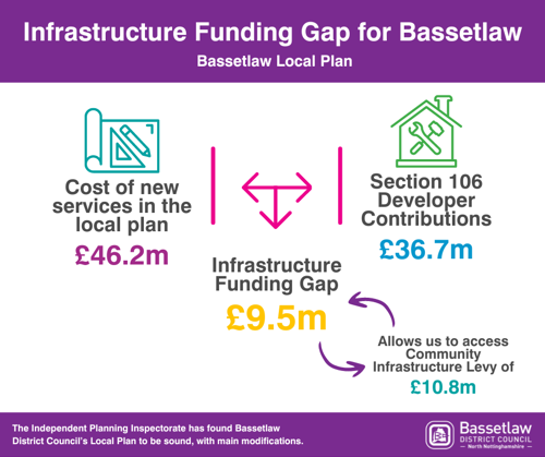
The cost of new services in the local plan (£46.2m) - Section 106 Developer Contributions (£36.7m) = Infrastructure Funding Gap (£9.5m)*. Allows us to access Community Infrastructure Levy of £10.8m.
Why doesn't the Local Plan ask for CIL funding for Peaks Hill Farm, Ordsall South and Trinity Farm?
The Local Plan asks for lots of infrastructure to support new building on the Peaks Hill Farm, Ordsall South and Trinity Farm sites. The Council has taken the decision not to ask for CIL funding from these sites. This is because CIL monies are not tied to specific areas or developments and can be spent anywhere in the district.
Instead, we have chosen to ask developers to fund the necessary infrastructure for these sites just through Section 106 Agreements. This means that the Council can help ensure that the money provided by the developers is only used in these areas.
Peaks Hill Farm Infrastructure Breakdown
Bus and Transport Improvements
New road link from Blyth Road to Carlton Road with a higher standard road. Will include cycle tracks and a bus route. A new bus service to Worksop town centre. Pedestrian and cycle links into Worksop.
Shops
Land will be provided for a new small supermarket and other shops or services.
Health Facilities
Money to improve doctors surgeries in the local area and money to improve Bassetlaw Hospital.
Tree Planting
For every house built on the site, the developer will provide five trees. These can be planted on site or in the local area.
Employment
5ha of employment land at the Peaks Hill Farm for business to develop.
Community Facilities
Community centre, indoor and outdoor sports facilities. The type of facilities will depend on the people living at the site and what they need.
Secondary School
The Local Plan contains safeguarded land for the provision of a secondary satellite school and the money needed to build it.
Nottinghamshire County Council will decide when this school is needed.
Flooding
Does Bassetlaw District Council 'allow' the building of housing developments on floodplains?
The Environment Agency splits the country up into different flood zones (Zone 1 is low probability of flooding, Zone 2 is medium probability, Zone 3a is high probability and Zone 3b is functional floodplain) and these are used by Councils when considering planning applications.
The Council must follow National Planning Policy (NPP) when considering planning applications. NPP requires that all new building should take place in the areas with the lowest risk of flooding.
When submitting planning applications, developers have to show that there are no reasonably available sites at a lower risk of flooding than the ones they want to build on. In Planning Law, this is known as the sequential test. Because Bassetlaw has enough suitable sites in the Local Plan to meet the demand for new housing, any proposals for residential development in Flood Zones 2 and 3 are unlikely to pass this test.
If the test is passed then the developer will still need to show that the site will be safe for its lifetime, not increase flood risk elsewhere and the benefits of the development outweigh the flood risk. The Council will always carefully consider the advice of the Environment Agency and the Lead Local Flood Authority in respect of any development in areas of high flood risk.
In Bassetlaw, the percentage of land in Flood Zone 3 that is currently used for housing is 0.09%. There is over 13,000ha of land in Bassetlaw that falls within Flood Zone 3, but 95.7% of this land is undeveloped. (about 12,500 ha).
The law is very clear when it comes to new development. There must be no increased flood risk as a result of new building. Our local plan has been examined and found sound by the Independent Planning Inspector. The Inspector raised no concerns that development at Ordsall South or other sites in Retford and Bassetlaw would increase the risk of flooding.
Last Updated on Wednesday, April 23, 2025
Related Items