Record of Determination
Dated: 20 April 2013
Informed by:
Part IIA B.20(c) Inspection of Potentially Contaminated Land, Former Gas Works, 63 Lincoln Road, Tuxford, Nottinghamshire. Report Number KL/0687/070418/P2 dated June 2007. Prepared by Ecus Ltd on behalf of Bassetlaw District Council.
Environmental Investigation Report, The Old Gas House Tuxford. Report Number D104016/E02S dated 19 December 2003. Prepared by Scott Wilson on behalf of Mr & Mrs Warner.
Remediation Method Statement 63 Lincoln Road, Tuxford. Report Number AC/50/20/A dated April 2013. Prepared by Bassetlaw District Council.
Bassetlaw District Council - Remediation Statement dated
Verified by:
Remediation Verification Report 63 Lincoln Road, Tuxford, dated November 2013. Prepared by G and J GeoEnvironmental on behalf of Bassetlaw District Council.
Record of determination that land is contaminated land
Bassetlaw District Council ('the Council') has determined that the land at:
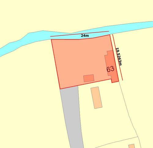
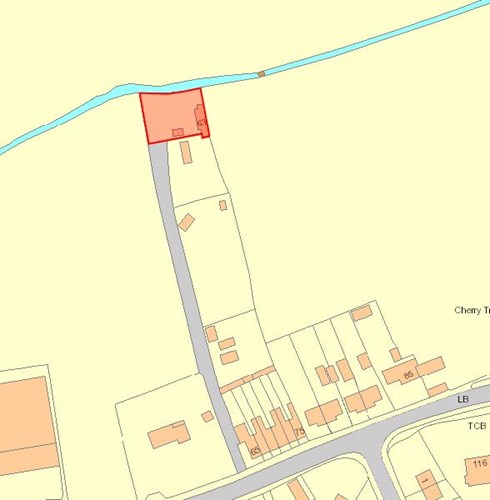
63 Lincoln Road, Tuxford, NG22 0JQ
Within the boundary marked in red on the attached plan, reference Appendix 1
Being land which is situated within the Council’s area, is contaminated land for the purposes of section 78A(2) of the Act because:
- The Council has identified a contaminant, a pathway and a receptor with respect to the current use of the land and is satisfied that this pollutant linkage presents a significant possibility of significant harm to that receptor.
A summary of the basis on which this determination has been made is set out in the Schedule to this record.
Mark Ladyman, Director of Community Services
Dated: 30 April 2013
Schedule
Pollutant Linkage
A pollutant linkage exists by reason of the following:
- Contaminant: Benzo(a)pyrene
- Pathway: Ingestion of soil, consumption of home-grown vegetables, dermal
- Receptor: Human beings
The pollutant linkage is a 'significant pollutant linkage' because the pollutant linkage presents a significant possibility of significant harm being caused to the receptor.
Evidence on which the determination is based
The site comprises a house and garden, occupying a roughly square plot of land approximately 130 m north of Lincoln Road, and accessed off Lincoln Road by a roughly surfaced driveway. The house is situated on the eastern boundary of the site. In front of the house is a gravel area, occupying the central and south western part of the site. The northern and southern parts of the site are occupied by a grassed garden area. A circular feature defined by a series of stone sets in the centre of the north garden is known to be the former location of the gas holder.
Wooden sheds are located in the northeast and northwest corners of the site. In the garden area, the grass peters out to the north, where a dark grey solid material replaces it at the surface. Piles of bricks are present on this area, together with assorted garden and construction equipment. The site boundary to the north is formed by a brick wall, beyond which is a stream, flowing west to east. To the east, the site is bounded by the rear wall of the house. The southern site boundary is defined by a fence with a shed at the south western point. There is a small pond at the eastern boundary. Hedges and a fence form the boundary to the west. The site is generally flat. The off-site access road slopes down from Lincoln Road in a northerly direction towards the site.
The gas works is present on historical maps at the site for the years 1885 and 1898. The maps show the site to be occupied by the gas works, including gas holder, with the building currently occupying the site in its present day position. On the map of 1918 the site is no longer shown to be occupied by the gas works; however buildings are present, including the present day house. It has also been confirmed that the house was the original gas manager’s house which is occupied as a private residence. The house was extended in 2004 with the addition of a two-storey extension on the south facing elevation.
In 2003 a site investigation was required by Building Control following an application for proposed extensions and alterations, following the grant of the erection of a two-storey extension.
See report: Environmental Investigation Report, The Old Gas House Tuxford. Report Number D104016/E02S dated 19th December 2003. Prepared by Scott Wilson on behalf of Ms Warner.
The site investigation indicated the presence of some typical gasworks contaminants.
It was agreed for the soil under and around the extension to be removed and disposed of, prior to building works.
In 2006 the contaminated land officer applied for a DEFRA capital grant for the investigation of the site under part 2A, Environmental Protection Act 1990, which was conducted in 2007.
See report: Part IIA B.20(c) Inspection of Potentially Contaminated Land, Former Gas Works, 63 Lincoln Road, Tuxford, Nottinghamshire. Report Number KL/0687/070418/P2 dated June 2007. Prepared by Ecus Ltd on behalf of Bassetlaw District Council.
The work carried out included:
- Obtaining soil samples
- Submission of samples for chemical analysis
- Production of a factual report (See above)
- Statistical analysis of the investigation results (concentration of contaminant in soil at which the 95th percentile predicted average daily exposure calculation) in line with EA provided software 'CLEA model', using CLEA guidance documents on the toxicity, where
- Comparison against relevant assessment criteria for contaminants
- Conceptual site model, and risk assessment using the statistical model from CIEH and guidance ‘Contaminated Land: Applications in Real Environments’ (CL:AIRE)
- Summary of significant contaminant linkages
Assessment of the evidence
- There was evidence of made ground in all the trial holes across the site
- Soil samples taken, showed evidence of elevated levels of arsenic, lead, phenol, benzo(a)pyrene, dibenzo(a,h)anthracene, naphthalene and cyanide.
- The 2007 B20(c) Inspection of Potentially Contaminated Land Former Gas Works, 63 Lincoln Road, Tuxford, Nottinghamshire by ECUS Ltd, concluded that the conceptual models selected in defining the SGV and GAC adopted are considered to be representative of the conditions at the site and it is considered likely that the generation of Site Specific Assessment Criteria would not lead to significant alteration to the list of substances considered to be of concern following the initial screening.
- The Council has based this determination upon the effect on human receptors.
- The Council has identified a significant pollutant linkage comprising a contaminant, a pathway and a receptor and is satisfied that as a result of the pollutant linkage there is significant possibility of significant harm being caused to the health of residents at 63 Lincoln Road, Tuxford
- The Council is satisfied that, on the basis of the risk identified in (e) above, remediation is necessary to reduce the risk of long term exposure to the soil at 63 Lincoln Road, Tuxford
How the requirements of the Statutory Guidance have been met
The Council has satisfied the requirements of the Statutory Guidance given in the Environmental Protection Act 1990, Part 2A, Contaminated Land Statutory Guidance 2012 by:
- Determining, in accordance with the guidance set out in section 5, the question of what harm is to be regarded as significant and the question of whether the possibility of significant harm being caused is ‘significant’. The Council has identified the land as being contaminated by determining that a significant pollutant linkage exists. The Council has relied upon the ECUS report ‘KL/0687/070418/P2 B.20(c) Inspection of Potentially Contaminated Land, Former Gas Works, 63 Lincoln Road, Tuxford, Nottinghamshire dated June 2007’ to demonstrate that:
- An established approach to the risk assessment of the contaminant- pathway-receptor concept has been followed in accordance with paragraphs 3.8 to 3.11 of section 3.
- The possible harm is significant, as defined in section 4.2, paragraph 4.10 to 4.15, through the establishment of a ‘human health effect’.
- There is a significant possibility of significant harm, as defined in paragraph 4.16 to 4.18, due to the amount of the contaminant that a human receptor might take in, or be otherwise exposed to as a result of the pathway, representing an unacceptable intake, or direct bodily contact, assessed on the basis of relevant information on the toxicological properties of that pollutant.
- Complying with the guidance in section 5, paragraph 5.6 and 5.7 in determining that the garden at 63 Lincoln Road, Tuxford appears to be contaminated land.
- The area of the contaminated land is clearly marked on the plan attached as Appendix 1.
- In making the determination that there is significant possibility of significant harm, the Council has identified a significant pollution linkage as set out above relied upon the ECUS report KL/0687/070418/P2 B.20(c) Inspection of Potentially Contaminated Land, Former Gas Works, 63 Lincoln Road, Tuxford, Nottinghamshire, dated June 2007:
- As scientific and technical evidence of the risk arising from the pollutant linkage
- For the conclusion that it is considered that the concentrations of contaminants at the site are sufficient to represent a significant possibility of significant harm to the site residents via the identified exposure pathways and that consideration is given to the status of the site under Part IIA of the Environmental Protection Act 1990, and
- To be satisfied that an adequate scientific and technical assessment using appropriate and scientifically based guideline values (the use of which has been in accordance with the guidance) has been undertaken to show that there is a significant possibility of significant harm, and the Council is satisfied that there are no suitable and sufficient risk management strategies in place to prevent such harm.
Appendix 1
Last Updated on Wednesday, May 8, 2024