Contents
- Foreword
- Executive Summary
- Introduction
- Characteristics of Bassetlaw
- Overall Aims and Objectives
- Priority Actions and Timescales
- Work Programme
- Procedures
- General Liaison and Communication
- Liability and Enforcement
- Information Management
- Review Mechanisms
- References
- Appendix 1
- Appendix 2
- Appendix 3
- Appendix 4
- Appendix 5
- Appendix 6
- Appendix 7
- Appendix 8
- Appendix 9
Foreword
"The quality of our land in Bassetlaw District is important to all of us, in terms of public health, ensuring continuing economic prosperity and enabling residents to enjoy our public spaces safely.
One of the council‟s overall objectives is to control threats to public health and the environment that could arise from contaminated land. This strategy sets out how we aim to achieve that.
We need to be able to identify where potentially hazardous sites might lie, assess the risks that they could pose to the community, and prioritise them so that the council can focus resources on where the risk is greatest.
This is a large task, but I am confident that the steps described in this strategy document will lead to better protection of our land, and of the people and the environment of Bassetlaw District."
Councillor Julie Leigh (Cabinet Member for Environment and Leisure)
Executive Summary
This strategy document details how Bassetlaw District Council will manage the duties it has in relation to contaminated land and potentially contaminated land sites within the district. These duties are contained within Part 2A of the Environmental Protection Act 1990.
Bassetlaw District Council first published a contaminated land strategy in July 2001, to detail how the council would take a rational, ordered and efficient approach to the inspection and investigation of land contamination. This revised strategy has been produced following a major revision to the statutory guidance in April 2012 and also takes into account other legislative changes since 2001.
The council has used all available information and a risk based approach during the initial screening process and will continue to do so when conducting any detailed inspection of sites to identify contaminated land. A rolling inspection programme will be undertaken, running until June 2015, with the council maintaining a public register of any land designated as contaminated.
The primary regulator in respect of these powers is the local authority, although it may be necessary to work with other organisations, particularly the Environment Agency in order to make a formal decision on contaminated land.
Under the definition contained within the legislation, in order for land to be designated as contaminated, a site must have both a pathway, by which significant harm may be caused (from the contaminant) and a specified receptor on which significant harm can be inflicted. If either the pathway or the receptor is missing from the contaminant linkage, the site may be in a contaminative state but cannot be designated as contaminated land. It is likely therefore, that only a very small proportion of sites will be designated as contaminated sites under the strict definition of contaminated land.
The identification of contaminated land will, therefore, be based firmly on the principles of risk assessment. Significant and imminent risks to human health will always be given the highest priority.
Potentially contaminated land will, prior to any detailed investigation, be prioritised and categorised according to a preliminary assessment of risk. This is to ensure that all further investigative work relates directly to the seriousness of the potential risk, so that the most pressing problems are identified and quantified first.
The council‟s approach in the main will be to seek voluntary remedial action (without the need for enforcement action) of any contaminated land where possible. An extensive consultation process will be completed and ample encouragement given to arrive at an informal solution.
The process of investigating and remediating land will ensure that all land in the district is suitable for use and does not pose unacceptable risks to people, the environment, water and property.
Introduction
Contaminated land is an issue which impinges upon all areas of Bassetlaw District Council's business and one which requires expertise from a variety of disciplines. It effects property transactions, marketing issues, planning, building control and even maintenance/works contracts all over the district. To be effective, the strategy must encompass all of these areas and provide a clear framework within which all departments must operate.
The statutory regime for the identification and remediation of contaminated land (under Part IIA of the Environmental Protection Act (EPA) 1990) has been implemented by Local Authorities since 2000. Under this regime, the Council is required to inspect land in its district for contamination. In July 2001 Bassetlaw District Council submitted a written strategy to the Environment Agency detailing how the authority will take a rational, ordered and efficient approach to this inspection. Following the publication of new statutory guidance produced by DEFRA in April 2012, a review and update of the strategy was required. The following document is Bassetlaw District Council‟s Contaminated Land Inspection Strategy, which details the authority‟s approach to dealing with its obligations under the contaminated land regime.
Background to the Legislation
The UK has a legacy of land contamination arising from past industrial development. Various industrial practices have led to substances being in, on or under land such as tars, heavy metals, organic compounds and mining materials. In addition, landfilling of waste sometimes took place without adequate precautions against the escape of landfill gases and leaching of materials. The previous regulatory system for dealing with contaminated land led in some instances to over prescriptive remediation being demanded to ensure public safety and as a result emphasised the need for a new system of regulation.
The Government, in its response to the 11th report of the Royal Commission on Environmental Pollution in 1985, announced that the Department of the Environment was preparing a circular on the planning aspects of contaminated land. The draft of the circular stated that:
"Even before a planning application is made, informal discussions between an applicant and the local planning authority are very helpful. The possibility that the land might be contaminated may thus be brought to the attention of the applicant at this stage, and the implications explained."
In 1988 the Town & Country Planning (General Development) Order required local planning authorities to consult with waste disposal authorities if development was proposed within 250 metres of land that had been used to deposit refuse within the last 30 years. Thus suggesting that it would be advantageous for the planning authorities to have available a list of potentially contaminated sites.
In January 1990 the House of Commons Environment Committee published its first report on contaminated land. This document, for the first time, expressed concern that the Government‟s suitable for use approach, “... may be underestimating a genuine environmental problem and misdirecting effort and resources”. The committee produced 29 recommendations, including the proposals that:
"The Department of the Environment concern itself with all land which has been so contaminated as to be a potential hazard to health or the environment regardless of the use to which it is to be put, and;
“The Government bring forward legislation to lay on local authorities a duty to seek out and compile registers of contaminated land."
Immediately following the House of Commons report the Environmental Protection Act 1990 had at section 143, a requirement for local authorities to compile, „Public registers of land which may be contaminated‟. If enacted this would have required local authorities to maintain registers of land, which was, or may have been contaminated, as a result of previous (specified) uses. In March 1992 however, the concern about the blighting effect of such registers resulted in a press release published by the Secretary of State delaying the introduction of section 143 stating:
"The Government were concerned about suggestions that land values would be unfairly blighted because of the perception of the registers."
Subsequently, in July 1992, draft regulations were released with significantly reduced categories of, contaminative uses, “.... to those where there is a very high probability that all land subject to those uses is contaminated unless it has been appropriately treated”. It was estimated that land covered by the registers would be only 10 to 15% of the area previously envisaged. This, however, still did not satisfy the city, so on the 24th of March 1993 the new Secretary of State (Michael Howard) announced that the proposals for contaminated land registers were to be withdrawn and a belt and braces review of land pollution responsibilities to be undertaken.
This resulted in the Department of the Environment consultation paper, Paying For our Past (March 1994), which elicited no less than 349 responses. The outcome of this was the policy document, Framework for Contaminated Land, published in November 1994. This useful review emphasised a number of key points:
- The Government was committed to the 'polluter pays principle' and, 'suitable for use approach'
- Concern related to past pollution only (there were effective regimes in place to control future sources of land pollution)
- Action should only be taken where the contamination posed actual or potential risks to health or the environment and there are affordable ways of doing so, and
- The long standing statutory nuisance powers had provided an essentially sound basis for dealing with contaminated land
It was also made clear that the Government wished to:
- Encourage a market in contaminated land;
- Encourage its development, and
- That multi functionality was neither sensible nor feasible.
The proposed new legislation was first published in June 1995 in the form of section 57 of the Environment Act which amended the Environmental Protection Act 1990 by introducing a new Part IIA. After lengthy consultation on statutory guidance this came into force on 1st April 2000.
The Contaminated Land (England) Regulations 2006 were introduced to elaborate on various details of the Part 2A regime, such as dealing with issues of what qualifies as a “special site”; public registers; remediation notices; and the rules for how appeals can be made against decisions taken under the Part 2A regime.
In April 2012 DEFRA published new statutory guidance which intended to explain how local authorities should implement the regime, including how they should go about deciding whether land is contaminated land in the legal sense of the term. This revised statutory guidance while still taking a precautionary approach allows regulators to make quicker decisions about whether land is contaminated under Part IIA preventing costly remediation operations being undertaken unnecessarily. It also offers better protection against potential health impacts by concentrating on the sites where action is actually needed.
Explanation of Terms
The legislation and guidance is very heavily punctuated with many complex and often unusual terms. To assist in the interpretation of these an extensive glossary has been included in DETR Circular 2/2000, Environmental Protection Act 1990: Part IIA Contaminated Land. (For convenience this has been reproduced in Appendix 1 of this strategy document).
National Objectives of the Regime
The Government believes contaminated land to be “an archetypal example of our failure in the past to move towards sustainable development”. The new regime is based upon a set of principles that include „suitable for use‟ standards of remediation, the „polluter pays‟ principle for allocating liability and a "risk based‟ approach to the assessment of contamination.
The first priority on land contamination has therefore been specified as the prevention of new contamination via proposed and existing pollution control regimes.
Secondly there are three stated objectives underlying the "suitable for use‟ approach to the remediation of contaminated land, as follows:
- To identify and remove unacceptable risks to human health and the environment;
- To seek to bring damaged land back into beneficial use; and
- To seek to ensure that the cost burdens faced by individuals, companies and society as a whole are proportionate, manageable and economically sustainable.
The suitable for use approach recognises that risk can only be satisfactorily assessed in the context of a specific use with the aim of maintaining an acceptable level of risk at minimum cost, thereby, “not disturbing social, economic and environmental priorities”.
The specific stated objectives of the regime are:
- To improve the focus and transparency of the controls, ensuring authorities take a strategic approach to problems of land contamination;
- To enable all problems resulting from contamination to be handled as part of the same process (previously separate regulatory action was needed to protect human health and to protect the water environment);
- To increase the consistency of approach taken by different authorities; and
- To provide a more tailored regulatory mechanism, including liability rules, better able to reflect the complexity and range of circumstances found on individual sites.
In addition to providing a more secure basis for direct regulatory action, the Government considers that the clarity and consistency of the regime, in comparison with its predecessors, is also likely to encourage voluntary remediation. It is intended that companies responsible for contamination should assess the likely requirements of regulators and plan remediation in advance of regulatory action.
There will also be significant incentive to undertake voluntary remediation in that the right to exemption to pay Landfill Tax will be removed once enforcement action has commenced.
The regime has also assisted developers of contaminated land by reducing uncertainties about so called, “residual liabilities”, in particular it should:
- Reinforce the suitable use approach, enabling developers to design and implement appropriate and cost-effective remediation schemes as part of their redevelopment projects;
- Clarify the circumstances in which future regulatory intervention might be necessary (for example, if the initial remediation scheme proved not to be effective in the long term); and
- Set out the framework for statutory liabilities to pay for any further remediation should that be necessary.
Local Objectives
Bassetlaw District Council is implementing Part IIA of the Environmental Protection Act 1990, which compliments the Council‟s own corporate aims and objectives.
Bassetlaw is committed to its key Mission Statement, which is:
"We aim to secure the best quality of life for everyone in Bassetlaw"
and a vision to deliver:
"A dynamic district where people live, work and prosper and the council works in partnership with others to develop a better quality of life for all".
Bassetlaw is also focused on four ambitions, which this strategy contributes towards, these are:
- Economic Regeneration of our District
- Quality Housing and Local Environment
- Involved Communities and Locality Working
- A Well-Run Council
In 2010 Bassetlaw District Council adopted its Sustainable Community Strategy for the period 2010 - 2020. This strategic plan establishes Bassetlaw District Council‟s determination to improve and promote the following eight priority policy areas:
- Enterprising Communities
- Learning Communities
- Sustainable Communities
- Healthier Communities
- Stronger Communities
- Safer Communities
- Supporting Children and Young People
- Accessible Communities
These key areas are not independent of one another – there is a great deal of interrelationship between them. They also reflect central government policy and the priorities of Nottinghamshire as a whole, outlined in the Nottinghamshire Sustainable Community Strategy 2010-2020.
This Inspection Strategy is presented in the context of Bassetlaw‟s Strategic Plan. Six of the priority policy areas are particularly relevant to this strategy document, as follows:
Enterprising Communities - Regenerate Key Areas of Bassetlaw
By encouraging brownfield re-development through voluntary remediation and providing specialist advice to potential developers, contaminated land can be safely recycled to the benefit of the local community.
Sustainable Communities - Conserve and Expand Areas of Open Green Space
The identification and safe re-use of contaminated land is an important part in the sustainable development of Bassetlaw‟s area. The contaminated land inspection strategy will make an increasingly significant contribution to sustainable development within Bassetlaw.
Supporting Children and Young People - Ensure the Safety of Children and Young People and Reduce the Risks to Children and Young People.
Much land contamination has been present for long periods of time. Limited controls were placed on land which poses significant risks. The strategy will ensure that the risks from such land is identified and reduced or removed.
Similarly, Bassetlaw's Core Strategy sets out 10 strategic objectives, four of which this Inspection Strategy will assist in the achievement of. These are:
- SO3 To prioritise the community regeneration opportunities available in Harworth, Bircotes, Misterton and Carlton-in-Lindrick / Langold by developing brownfield sites in these settlements in advance of greenfield allocations.
- S05 To ensure the continued viability of Bassetlaw's rural settlements through the protection and enhancement in the levels, of local services and facilities and support for enterprises requiring a rural location.
- S08 To protect Bassetlaw's natural environment by maintaining, conserving and enhancing its characteristic landscapes, biodiversity, habitats and species and seeking quantitative and qualitative growth in the green infrastructure network across and beyond the District.
- S09 To protect and enhance Bassetlaw's heritage assets, identify those of local significance, advance characterisation and understanding of heritage asset significance, reduce the number of heritage assets at risk and ensure that development is managed in a way that sustains or enhances the significance of heritage assets and their setting.
Several other key corporate, regional and county strategies influence this contaminated land inspection strategy.
The East Midlands Regional Plan provides a broad development strategy for the region.
The plan seeks to realise the following vision for the Northern Sub-Area, in which Bassetlaw is located:
- The Northern Sub-Area will be an area containing vibrant towns and smaller centres which are easily accessible from major transport routes, which is rich in carefully protected natural and cultural assets and supporting a viable population and employment base within sustainable communities.
- Of particular relevance to Bassetlaw are: policies 7 (Regeneration of the Northern Sub-Area); 13a (Regional Housing Provision); 19 (Regional Priorities for Regeneration);
- and Northern SRS policies 1 (Sub-Regional Development Priorities); 2 (Supporting the Roles of Towns and Village Centres); and 3 (Sub-Regional Employment Regeneration Priorities). While there are no targets for employment land provision set out in the RSS, these policies do seek to ensure the delivery of 350 houses a year within Bassetlaw (7000 houses in total between 2006- 2026).
While the Core Strategy and Development Management Policies document will set out a local vision for the area, and specific policies to achieve that vision, we must also ensure that the document conforms to national planning policy. National planning policy is set out in the National Planning Policy Framework (NPPF), which can be found via the website http://www.communities.gov.uk. A key message within this document is delivering Sustainable Development, which makes it clear that sustainable development is the core principle underpinning planning. In simple terms, this means ensuring that development meets the needs of the present without compromising the ability of future generations to meet their own needs.
These various strategies as well as providing support to Bassetlaw‟s Strategic Plan show that the identification and safe re-use of contaminated land plays a key part in the sustainable development of Bassetlaw and its surrounding area.
Regulatory Context of Contaminated Land
The Act itself states at section 78B (1) that:
Every local authority shall cause its area to be inspected from time to time for the purpose -
- Of identifying contaminated land; and
- Of enabling the authority to decide whether any such land is land that is required to be a special site (see Appendix 2).
Section 78B (2) states that the authorities must act in accordance with guidance issued by the Secretary of State in this respect. Statutory Guidance has been published within the Department for Environment, Food and Rural Affairs, Environmental Protection Act 1990: Part 2A, Contaminated Land Statutory Guidance document.
The statutory guidance makes clear that in order to carry out this duty authorities must produce a formal contaminated land strategy document which clearly sets out how land which merits detailed individual inspection will be identified in an ordered, rational and efficient manner, and in what time scale.
The strategy was first completed, formally adopted by Bassetlaw District Council, and published in July 2001. The strategy has now been reviewed and updated. Copies of the final document must also be forwarded to the Environment Agency. Subsequently the strategy must be kept under periodic review.
In order to satisfy the far reaching objectives of the regime it will be necessary to investigate land throughout the whole of the district and collate significant volumes of information. This will ultimately enable Bassetlaw District Council to make the sometimes difficult and inevitably complex decisions relating to its condition, the risks it presents and who may be liable for it by law. This strategy is the foundation of that process and seeks to express as clearly as possible how each stage will be addressed.
Regulatory Role of Bassetlaw District Council
The primary regulator in respect of these powers is the local authority. In Bassetlaw District Council, the strategy will be under the control of the Director of Community Services. It should be noted that this is a complex and demanding enforcement role that will be carried out in accordance with the responsibilities laid upon the Authority by this particular piece of legislation and the Cabinet Office Enforcement Concordat of 1998.
The statutory guidance states:
“Inspection duty and the decision whether land is contaminated land remains the sole responsibility of the authority”
This is a significant responsibility that reflects existing local authority duties under the statutory nuisance regime and Town & Country Planning, development control. The role in broad terms includes:
- To prepare a strategy for the inspection of contaminated land in the area
- To cause the area to be inspected to identify potentially contaminated sites
- To determine whether any particular site is contaminated (by definition)
- To determine whether any such land should be designated a „special site‟ (see Appendix 2)
- To act as enforcing authority for contaminated land not designated as a „special site‟
Where the presence of contaminated land has been confirmed, the enforcing authority must:
- Prepare a written record of any determination that particular land is contaminated land
- Establish who should bear responsibility for remediation (appropriate person(s))
- Decide after consultation what must be done in the form of remediation and ensure it is effectively carried out
- Determine liability for the costs of the remedial works
- Maintain a public register of regulatory action in relation to contaminated land
Regulatory Role of the Environment Agency
The Environment Agency has four main roles in regulating contaminated land:
- To assist local authorities in identifying contaminated land (particularly where water pollution is involved)
- To provide information and advice to local authorities, including site specific guidance on contaminated land where requested
- To act as enforcing authority for contaminated land designated a „special site‟
- To publish periodic reports on contaminated land nationally
A special site has a statutory definition (see Appendix 2). In general, special sites have had uses where the Environment Agency is likely to already have a regulatory responsibility, for example sites regulated under the Integrated Pollution Control regime. . Special sites are not necessarily more contaminated than other kinds of site. Examples are nuclear sites, MOD sites, oil refineries and sites that may cause pollution of drinking water resources.
A memorandum of understanding has been drawn up between the Environment Agency and the Local Government Association (on behalf of all local authorities) that lays down the roles and responsibilities of both parties under Part IIA of the Environmental Protection Act 1990: Contaminated Land.
Definition of Contaminated Land Under Part 2A
Whether land is considered as contaminated will depend on the definition used. Section 78A(2) of Part IIA defines Contaminated land as:
“Any land which appears to the local authority in whose area it is situated to be in such a condition, by reason of substances in on or under the land, that -
Significant harm is being caused or there is a significant possibility of such harm being caused; or
Significant pollution of controlled waters is being caused, or there is a significant possibility of such pollution being caused”
The definition aims to enable the identification and remediation of land on which contamination is causing unacceptable risks to human health or the wider environment. Subsequently, the definition does not include all land where contamination may be present.
Within this document, all references to contaminated land take their meaning from this statutory definition.
What may and may not constitute the various categories of harm is described in the statutory guidance (see Appendix 3).
Controlled waters include inland freshwater, groundwater and coastal waters (for further information see Appendix 4).
Principles of Risk Assessment & Contaminant Linkages
The definition of contaminated land is based on the principles of risk assessment. The statutory guidance defines „risk‟ as the combination of:
- The likelihood that harm, or pollution of water, will occur as a result of contaminants in, on or under the land; and
- The scale and seriousness of such harm or pollution if it did occur
The Council must search its districts for land that has both sensitive receptors (i.e. something that may be harmed, see below) and sources of potential contamination. Where the Council has good reason to believe these both exist, it must undertake a formal risk assessment in accordance with established scientific principles in order to establish whether there is the potential for them coming together and causing harm or pollution as described. This is known as a contaminant linkage. If there is no contaminant linkage, the substance cannot cause harm.
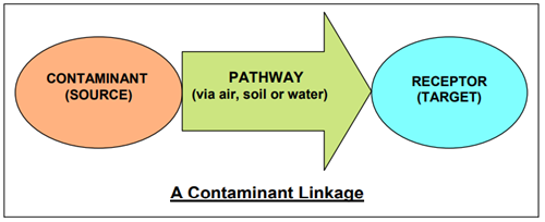
A “contaminant” is a substance which is in, on or under the land and which has the potential to cause significant harm to a relevant receptor, or to cause significant pollution of controlled waters.
A “receptor” is something that could be adversely affected by a contaminant, for example:
- a person,
- an organism,
- an ecosystem,
- property,
- controlled waters.
A “pathway” is a route by which a receptor is or might be affected by a contaminant.
All three elements of a contaminant linkage must exist in relation to particular land before the land can be considered potentially to be contaminated land under Part 2A, including evidence of the actual presence of contaminants. The term “significant contaminant linkage”, as used in the Guidance, means a contaminant linkage which gives rise to a level of risk sufficient to justify a piece of land being determined as contaminated land. The term “significant contaminant” means the contaminant which forms part of a significant contaminant linkage.
It is important to fully understand this concept, as it will form the basis of all future site investigation and prioritisation procedures.
Where the Council is satisfied that significant harm is occurring, or there is a significant possibility of such harm to land or controlled waters, it must declare that a significant contaminant linkage exists and that the land is therefore contaminated land by definition. In every case where the land does not fall within the category of a special site, the local authority must commence regulatory action.
The statutory guidance promotes a risk-based approach to dealing with potentially contaminated land in the UK. The aim of this type of approach is to protect human health and the environment without unnecessarily wasting finances on cleaning up sites that do not pose a significant risk.
This „suitable for use‟ approach acknowledges that the risk presented by a level of contamination will largely be dependent upon the use of the land, in addition to factors such as the geology of the site. Therefore, a site may be remediated to a level acceptable for use as a car park but not for residential use. Subsequently, risks need to be assessed on a site-by-site basis of the facts.
Land can only be considered contaminated if it impacts in a certain way on specified receptors. The receptors defined in the statutory guidance recognised as being potentially sensitive are:
- Human beings
- Ecological systems:
- Areas of Special Scientific Interest (Wildlife & Countryside Act 1981, section 28)
- National / Local Nature Reserves (Wildlife & Countryside Act 1981, section 35 /National Parks & Access to the Countryside Act 1949, Section 21)
- Marine Nature Reserves (Wildlife & Countryside Act 1981, section 3)
- European Sites (Conservation of Habitats and Species Regulations 2010 regulation 8)
- any habitat or site afforded policy protection under paragraph 6 of Planning Policy Statement (PPS 9) on nature conservation (i.e. candidate Special Areas of Conservation, potential Special Protection Areas and listed RAMSAR sites)
- Property:
- Buildings (including below ground)
- Ancient Monuments
- Property:
- All cops including timber
- Produce grown domestically or on allotments for consumption
- Livestock
- Other owned or domesticated animals
- Wild game subject to shooting or fishing rights
- Water:
- Territorial seawater (to three miles)
- Coastal waters
- Inland fresh waters (rivers, streams, lakes, including the bottom / bed if dry)
Ground Waters (Water Resources Act 1991 s104)
In summary, for contaminated land to exist the following are prerequisites:
- One or more contaminant substances
- One or more specified receptors
- At least one plausible pathway between contaminant and receptor (then a contaminant linkage exists)
- A good chance that the contaminant linkage will result in significant harm to one of the specified receptors
The Conceptual Site Model
The process of risk assessment involves understanding the risks presented by land, and the associated uncertainties. In practice, this understanding is usually developed and communicated in the form of a “conceptual site model” (CSM) which indicates all the contaminant linkages and uncertainties associated with each.
Strategic Approach to Identification of Contaminated Land
The Council is required to take a strategic approach to inspecting land in its area for contamination.
The statutory guidance requires that the approach adopted should:
- Be rational, ordered and efficient
- Be proportionate to the seriousness of any actual or potential risk
- Seek to ensure the most pressing and serious problems are located first
- Ensure resources are concentrated on investigation areas where the authority is most likely to identify contaminated land
- Ensure that the local authority efficiently identifies requirements for the detailed inspection of particular areas of land
In developing a strategic approach to the identification of contaminated land Bassetlaw District Council will need to have regard to its own local circumstances and in particular consider:
- The extent to which any specified receptors (as defined in list above) are likely to be found in the district
- The history, scale and nature of industrial or other potentially contaminative uses
- The extent to which any of the specified receptors is likely to be exposed to a contaminant
- The extent to which information on land contamination is already available
- The extent to which remedial action has already been taken by Bassetlaw District Council or others to deal with land contamination problems
In undertaking its duties to inspect the district under section 78B (1) of the Act, the Council will take into consideration the particular characteristics of the area, including:
- Relevant geology, hydro geology and hydrology
- The location of:
- sensitive water receptors
- sensitive property receptors
- relevant ecological receptors
- all existing human receptors and;
- Potential sources of contamination
Situations Where This Regime Does Not Apply
The primary aim of the Government is to prevent new contamination occurring. There are several situations therefore where existing pollution control legislation would apply to control the effects of land contamination:
- The Environmental Damage (Prevention and Remediation) Regulations 2009 are a result of the implementation of the European Directive on Environmental Liability (2004/35).
They are based on the principle of „the polluter pays‟, where those responsible for a pollution incident are required to prevent and, where necessary, remedy any environmental damage caused. The emphasis is on the „operator‟ identifying where or when there is imminent threat or actual damage to the environment, and taking immediate action.
Environmental damage is considered to be:
- Serious damage to surface or ground water.
- Serious damage to EU-protected natural habitats or species.
- Contamination of land with a significant risk of harm to human health.
The regulations are not retrospective and will only be applied to damage caused after their implementation.
-
Pollution Prevention and Control (Environmental Protection Act 1990 Part I/ Prescribed Processes and Environmental Permitting (England and Wales) Regulations 2010) - This regime has been introduced to replace IPC, and includes the specific requirement that permits for industrial plants and installations must include conditions to prevent the pollution of soil; and there are also requirements in relation to the land filling of waste.
-
Waste Management Licensing (Environmental Protection Act 1990 Part II) - All waste disposal and processing sites (including scrapyards) should be subject to licensing. Contamination causing harm, or pollution of controlled waters, should be dealt with as a breach of the conditions of the licence. In exceptional circumstances, where the problem arises from an unlicensed activity, it is possible that Part IIA could apply. An example of this would be a leak from an oil tank outside the tipping area. Where there has been an illegal tipping of controlled waste (fly tipping) this should also be dealt with under the Environmental Protection Act 1990, Part II (section 59).
-
Discharge Consents (Water Resources Act 1991 Part III) - No remediation notice can require action to be taken that would affect a discharge authorised by consent.
-
Risk of Harm to Employees - Where there is a risk of harm to persons at work from land contamination, this should be dealt with under the Health and Safety at Work etc Act 1974. The enforcing authority will be either the Health & Safety Executive or this Council depending on the work activity.
- Change of Land Use - Where land becomes a risk to potential new receptors as a result of a change of use, the Town & Country Planning Development Control regime will continue to apply as before. The National Planning Policy Framework (2012) states that: Planning policies and decisions should ensure that:
- the site is suitable for its new use taking account of ground conditions and land instability, including from natural hazards or former activities such as mining, pollution arising from previous uses and any proposals for mitigation including land remediation or impacts on the natural environment arising from that remediation;
- after remediation, as a minimum, land should not be capable of being determined as contaminated land under Part IIA of the Environmental Protection Act 1990; and
- adequate site investigation information, prepared by a competent person, is presented.
The Building Regulations (made under the Building Act 1984) requires measures to be taken to protect new buildings, and their future occupants, from the effects of contamination. “Approved Document Part C (Site Preparation and Resistance to Moisture)” published in 2004 gives guidance on these requirements.
In addition there are several other situations where the relationship with Part IIA may need clarification:
- Contaminated Food (Food Standards Act 1999) - Part I of the Food and Environment Protection Act 1985 gave Ministers emergency powers to prevent the growing of food on, inter alia, contaminated land. Following the establishment of the Food Standards Agency this power is now vested in the Secretary of State. Where the Council suspects crops may be affected from contaminated land to such an extent they may be unfit to eat, they will consult the Food Standards Agency and Department for Environment, Food and Rural Affairs (DEFRA) to establish whether an emergency order may be necessary. It should be noted, however, that remediation of the site if necessary would be carried out through the powers in Part IIA.
- Radioactivity - The Part IIA Contaminated Land Regime was extended to cover radioactivity in 2006 in England and Wales. The Council will liaise with the Environment Agency where radioactive contamination is suspected or confirmed.
- Organisms - Part IIA does not apply to contamination caused by organisms such as bacteria, viruses or protozoa, as they do not fall within the definition of substances. This could affect land contaminated with Anthrax spores, Ecoli, etc. The Council will liaise with the Environment Agency in relation to MOD land and DEFRA on all other sites. It should be noted that even though contaminated sites used in connection with biological weapons must be designated Special Sites (see Appendix 1); this applies only to non-biological contamination.
- Statutory Nuisance - (Environmental Protection Act 1990 Part III) - The relationship between Part IIA and statutory nuisance is not straight forward. If land is declared contaminated land by definition, it cannot be considered a statutory nuisance. This is understandable and ensures there is no duplication or confusion between the two regimes. If however, the land is investigated and found not to be contaminated land but, “land in a contaminated state” (defined as land where there are substances in, on or under the land which are causing harm, or there is a possibility of harm being caused), it also cannot be considered a statutory nuisance for the purposes of Part III of the Act. Precisely in what circumstances might land be declared, “in a contaminated state”, is not clear. Where land is not contaminated land or in a contaminated state, but is causing a nuisance from smell, it could be considered a statutory nuisance as before.
Inspection Strategy Development
The identification of contaminated land will be carried out in an ordered, rational and efficient manner based firmly on the principles of risk assessment. Significant and imminent risks to human health will always be given the highest priority.
Any strategy on contaminated land can only be as good as the information upon which it is based. Due to Bassetlaw‟s proactive approach to contaminated land, the Environmental Health Service has collated large amounts of information on sites that have the potential to cause contamination due to a former land use. In line with the statutory guidance, the inspection strategy will therefore be focused on areas where contaminated land is thought likely to exist and on industries specific to the area.
In order to meet these requirements, the framework for the original inspection strategy was partially developed through the Nottinghamshire Contaminated Land Sub-Group. The group consists of Environmental Health representatives from each of the eight Local Authorities that form Nottinghamshire. There are also representatives from Leicester City Council and The Environment Agency (EA). The sub-group reports to the Nottinghamshire Pollution Working Group (NPWG) that in turn reports to the Nottinghamshire Chief Environmental Health Officers Group. The NPWG has been in existence since the late 1980‟s. It was established to provide technical and practical information on pollution matters for the Chief Officers Group. It enables a collaboration of expertise across the County to provide a coherent approach to environmental issues.
The Sub-Group was formed to concentrate solely on contaminated land to enable officers to share information and expertise to provide a consistent and efficient approach to the implementation of Part IIA of the Environmental Protection Act 1990. In pursuance of this, it was decided that certain sections of the strategy were drafted collectively. Each local authority drafted a section of the strategy document, using “Contaminated Land Inspection Strategies – Technical Advice for Local Authorities” issued by the Department of the Environment, Transport and the Regions for reference. The aim of this exercise was to provide each local authority with a detailed framework on which to base its own strategy in order to promote a consistent approach across the county. Each section was discussed and amended where appropriate to produce a structured and consistent strategy based on the collective expertise of the eight local authorities.
Internal Team Responsibilities
Within Bassetlaw District Council, the Environment and Health Services has responsibility for the implementation of the Contaminated Land Regime. When the regime was first implemented in 2001 an Environmental Health Officer was seconded to undertake the work necessary to produce the initial Contaminated Land Inspection Strategy. During the development of the strategy it became apparent that the most appropriate way of meeting the statutory obligations of the new contaminated land regime would be to have a designated officer tasked with delivering the inspection strategy and co-ordinating the various links that other council services will have to the regime. A pollution control officer is now in post who has the responsibility of reviewing and implementing the strategy.
The Pollution Control Officer (Contaminated Land) will report directly to the Principal Environmental Health Manager (Food, Health and Safety), who in turn reports to the director of community services. This Pollution Control Officer will be responsible for the implementation of the strategy once approved by elected members and for coordinating any detailed site investigations that are required, overseeing any subsequent remediation work, ensuring data is managed correctly, consultation on planning applications and providing information on general enquiries. District Environmental Health and Technical Officers and Officers from other council services will support the Pollution Control Officer, where necessary. It is likely that private consultants, yet to be determined, may be required to carry out any detailed inspections of sites in order to assist in the determination of contaminated land, unless the necessary expertise can be found from within the Council. Any work of this nature will be co-ordinated by the Pollution Control Officer.
The Pollution Control Officer (Contaminated Land) can be contacted at:-
Environmental Health
Bassetlaw District Council
Queen's Building
Potter Street
Worksop
Nottinghamshire
S80 2AH
Tel: 01909 534423
This strategy impacts on potentially all departments of the Council and therefore to necessitate its smooth implementation formal working links with the following services have been formed:
Planning and Development Control
The inspection of the district will identify areas of potentially contaminated land which may already be developed, awaiting development, derelict, protected or green belt. This may result in the need to re-examine past development control files or identify development routes for contaminated sites that may subsequently impact on the Local Development Plan.
Building Control
Have the duty to enforce protection measures in new build projects to mitigate the impact of contamination on property. Information they hold will be essential to quantify risks.
Legal Services
This is a highly complex piece of legislation that could have significant implications for the Council, landowners and occupiers. The Solicitor‟s advice may be required on many aspects including those relating to enforcement, liability, powers of entry, data protection, access to information etc.
Information Technology
Significant volumes of data will need to be held both on database and geographical information systems. Support will be required on the use of these systems and data protection.
Finance
This legislation can have significant resource implications for the Council, both as an Enforcing Authority and landowner.
Environmental Health (Neighbourhoods Team)
May hold information on pollution incidents, reports and complaints relating to specific sites, which will need to be reviewed and able to provide assistance in enquiries and determination of contaminated land. Likely to be the first contact point for any complaints relating to issues of contaminated land.
Council Owned Land
Land owned by or in use and controlled by Estates, Housing, Leisure Services, Engineers, and Waste Management may be contaminated and require remediation. In addition planning may need to be consulted for issues relating to remediation and tree growth and impacts on eco-receptors.
Highways - responsibility of Nottinghamshire County Council
Land under highways, pavements, verges and common areas may be contaminated and present a risk to potential receptors. The regime may therefore impact on Nottinghamshire County Council as the Highways Authority must maintain registers under Part III of the New Roads and Street Works Act 1991 regarding streets with „‟special engineering difficulties”. This includes risks from contamination.
Progression of Inspection Strategy Through the Council
The progression of the Contaminated Land Inspection Strategy through the Council to its adoption and final publication has been as follows:
- Forward draft strategy for comments to external Statutory Consultees
- Submission of draft strategy for comments to Cabinet for comment and recommendations for consultation with the local community
- Submit amended strategy to Management Team for approval
- Forward amended strategy to executive Committee for approval, adoption and recommendation for formal publication
- Publish and publicise final version of the adopted strategy and submit to the Environment Agency
Characteristics of Bassetlaw
Characteristics of Bassetlaw District Council
This section gives background information about the area covered by Bassetlaw District Council. It also gives an indication of the local issues that need to be considered in order to identify the likely existence of a contaminant linkage and ultimately to make a determination on statutory contaminated land.
An overview of Bassetlaw District Council
Geographical Location
Bassetlaw District Council was established in 1974 and is responsible for local government in the areas formerly administered by Worksop Borough, Worksop Rural District, Retford Borough and Retford Rural District Councils. It is the most northerly District Council in Nottinghamshire, situated between agricultural Lincolnshire and industrial South Yorkshire. Bassetlaw‟s boundaries approximate 155km in total and coincide with major landscape features such as the River Trent on the east, which also forms the county boundary with Lincolnshire and the forests and parks of the Dukeries on the south. To the north and west, the district extends to the boundary with South Yorkshire. The A1/A1M runs the length of Bassetlaw District, between Worksop and Retford.
Bassetlaw‟s local authority neighbours are Bolsover and Mansfield to the south west, Newark and Sherwood to the south, West Lindsey to the east and Doncaster and Rotherham to the north and west respectively.
Size
Overall the district is 63,687 hectares. Bassetlaw occupies almost 30% of the County‟s area but has only 10% of the population.
Population Distribution
The 2010 population estimate records 111,315 residents within Bassetlaw, comprising 27 constituency wards and 70 parishes. The main economic and population centres are Worksop (population 41,450) and Retford (population 21,941). Populations in the remaining parishes are as follows: -
Table 1: Population figures based on the 2010 population estimates Office of National Statistics
| Parish | Population |
|---|---|
| Askham | 200 |
| Babworth | 1420 |
| Barnby Moor | 260 |
| Beckingham | 1215 |
| Bevercotes | 25 |
| Blyth | 1267 |
| Bole | 115 |
| Bothamsall | 195 |
| Carburton | 65 |
| Carlton-in-Lindrick | 5969 |
| Clarborough | 1140 |
| Clayworth | 285 |
| Clumber and Hardwick | 85 |
| Cottam | 95 |
| Cuckney | 285 |
| Dunham on Trent | 310 |
| East Drayton | 220 |
| East Markham | 1150 |
| East Retford | 21,941 |
| Eaton | 220 |
| Elkesley | 690 |
| Everton | 785 |
| Fledborough | 60 |
| Gamston | 305 |
| Gringley on the Hill | 675 |
| Grove | 110 |
| Harworth and Bircotes | 7693 |
| Haughton | 35 |
| Hayton | 415 |
| Headon-cum-Upton | 180 |
| Hodsock | 2550 |
| Holbeck | 310 |
| Laneham | 280 |
| Lound | 515 |
Bassetlaw’s Historical Development and Industrial Legacy
Worksop Area
As far as early records show, industries began in Worksop during the Middle Ages and were connected to products from the land such as malting, milling and timber. These basic industries, with certain modifications, have survived through to modern times. During the 17th and 18th centuries, Worksop was noted for its liquorice and a thriving trade developed. This industry gradually died out following more lucrative finds of liquorice in Pontefract.
Worksop benefited from the opening of the Chesterfield Canal in 1777, which gave a boost to local industries, allowing Worksop to expand. It also brought about a reduction in the price of coal due to reduced transport costs.
The early part of the 19th century saw the arrival of the railways with a corresponding great demand for timber (that was abundant in the area) and the first colliery was sunk at Shireoaks. This began a new era of industrial activity and growth in Worksop. By the end of the 19th century quarrying had commenced at Steetley both for magnesian and limestone. Shortly after the turn of the 20th century following the sinking of a shaft at Manton (1902) and the opening of a flour mill (Smiths) on Eastgate, a profound change took place in the town owing to the ease of access to these sites and the beginnings of the modern town took shape.
Maltkilns were present in Worksop as long ago as 1636 and probably for many years before that. The malting business being widely carried on due to much of the land being extensively devoted to the growth of barley. In medieval times, when Worksop Priory geographically formed the centre of a number of religious houses, Worksop was well noted for the quality of its malt. By the middle of the 19th century malting was the principal trade, with Worksop paying more duty than any other place in England. Various breweries owned a number of the maltkilns. Clinton Maltkilns (close to the railway station on Carlton Road, Worksop) was owned by a well-known maltster of Mirfield and Wakefield. The same maltster owned maltings at Gateford Road, Kiveton Park, Tuxford and Retford. By 1860s, 29 maltkilns were present in Worksop:-
- 5 near to the canal between Golden Ball and Bridge Place
- 6 were on or near Gateford Road
- 4 dispersed between Potter Street and Eastgate
- 3 were on Lowtown Street
- 2 on Abbey Street
- 1 each on Clarence Road, Carlton Road, Park Street and Castle Street
The malting business continued to flourish until the end of the 19th century. By the early 1900s an increase in the larger factory like maltkilns caused the smaller ones to go out of business and many of the buildings were subsequently demolished.
Flour milling was another occupation as old as the town of Worksop itself. It is likely that the first settlers ground grain by hand worked stones, but their successors harnessed the power of the River Ryton. In 1636 there were 3 water mills for flour milling, but by the end of the 19th century only 2 mills were still in business, Beard‟s Mill (a water mill fed by the River Ryton) and a steam mill at Gateford Road.
For centuries trees were felled in woodlands surrounding Worksop. Even until the early 18th century timber was the main house building material. Following the availability of brick, less timber was used, but it wasn‟t until the development of the Chesterfield Canal and the opening out of the railways that the local wood yards became an important source of employment. In 1897, there were 8 large timber firms in the town, some specialising as timber merchants, others as turners or chairmakers. By 1930s the last of the Worksop chairmaking had stopped.
Sand quarrying grew up in the Worksop area as a result of the geological structure of the locality. The Bunter Sandstone in the area is a deep stratum with a shallow overburden, which allowed three grades of sand to be quarried: medium or red sand, inferior and fine sand. Gateford Quarry produced sand for the steel industry whilst Sandy Lane Quarry provided for the building trade as well as the steel industry. Fine Sand was quarried from the site east of Owday Lane and a further sand quarry was Located at Kilton Hill.
Magnesian limestone has been quarried in the district due to the geological structure of the locality. A magnesian limestone belt that touches the western boundary of the Worksop area provided limestone for use in the Sheffield steel industry. Quarrying stone at Steetley goes back to the 12th century. Records for the quarry existed until 1880, with Steetley providing stone for the many ducal houses of the area, for York Minster and the Houses of Parliament. The growth of Steetley quarry resulted from the discovery that magnesian limestone could be converted into a refractory material suitable for furnace lining. In the late 1800s 2 refractories were started, one sited alongside Steetley Quarry the other in Sandy Lane and began producing bricks and tiles.
Coal mining has been an important industry for Worksop and consequently has helped to shape the settlements and landscape as we know it today. The sinking of the first shaft at Shireoaks colliery in 1859 brought coal mining to the town and before the end of the century collieries were also working at Steetley and Whitwell. In 1897 the first of the two shafts was sunk at the future Manton Colliery, which by 1907 was completely operational.
With the outbreak of the Second World War there was an increase in the commencement of heavy industry in the Worksop area. During the 1950s lighter manufacturing industries such as hosiery were introduced.
Retford Area
Retford has always been a market town receiving its Royal Charter in 1246. In 1766 the Great North Road was re-routed through Retford, further increasing the importance of the area around the market square and making it a highly desirable area to work and live.
Milling was Retford‟s earliest recorded industry, with the town building several windmills to take advantage of its position of being in the centre of a large corn growing area. The presence of so many mills created the need for machinery, which led to the setting up of several engineering works in the area. Surprisingly, sailmaking was another important early industry in and around Retford. Boats on the Trent used sails at a time when West Stockwith was a busy port. Narrow boats on the Chesterfield Canal were also equipped with sails for river work. Also, sailcloth was used on the early windmills before the wooden slatted sweeps were invented. The sailcloth was made from the flax that was widely grown in Nottinghamshire in the early 19th Century.
Retford's thriving market status created the demand for a variety of goods and trades such as:-
- Hatmakers
- Boot and shoemakers
- Saddlers
- Malsters
- Brewers
- Tinners
Retford's prosperity was afforded by the fact that it could supply most needs and services itself.
By the 1960s industries such as mining, forestry and agriculture accounted for 25% of the total employment in the whole area, with mining being regarded in Worksop as the basic industry.
Current Land Use Characteristics
The majority of Bassetlaw is rural in nature with a large number of attractive villages and towns and pleasant countryside. Bassetlaw‟s rural area accommodates around half of the population within 68 parish communities. The development of the District has been greatly influenced by the past reliance on coal mining. There are now no operational mines in Bassetlaw District; the last two were at Welbeck and Harworth, although Harworth could still re-open. The villages of Shireoaks, Rhodesia, Carlton, Langold and Harworth/Bircotes largely grew up to accommodate colliery workers. Both Retford and Worksop are also manufacturing centres. Traditional industries (textiles, metal goods, engineering, agriculture etc.) continue as significant sources of employment, but considerable progress has been made throughout the District in diversification into new sectors of employment in order to improve the economy and reduce the level of unemployment.
The town centres of Worksop and Retford contain the greatest concentrations of retail, commercial and business activities in Bassetlaw. Worksop‟s origins lie in heavy industry and coal mining, but both of these activities have declined, and the town is now mostly residential with some light industry. To the south of Worksop lies Clumber Park, part of Sherwood Forest. This area is mostly rural with large wooded areas.
Retford was originally a market town. It is now, like Worksop primarily residential, and contains some light industry although less than Worksop. The area east of Retford is flat, open country, mostly farmland, dotted with small villages. Along the eastern border at the side of the River Trent are two coal fired power stations, located at: West Burton and Cottam.
Residential Land Use
The total number of properties located throughout Bassetlaw is approximately 49,800, split mainly between the population centres of Worksop and Retford. Approximately 14% of the dwellings are council owned (6,938 at March 2011). In addition there are a number of privately owned permanent residential caravan sites (mobile home sites).
Industrial and Commercial Land Use
In general terms the Bassetlaw district can be divided into the more industrialised west and the agricultural east with its numerous villages, the A1 separating the two.
Local industries that have a fairly long association with Bassetlaw and that are still in operation include: coal mining, quarrying, glassware production, refractory products, printing works, rubber works, textile manufacture, engineering and waste processing.
Two of the former colliery sites (Manton and Shireoaks) have been cleared of buildings and the spoil heaps have been re-graded and have been planted with grass and trees for proposed leisure activities. In order to sustain and improve the economy of the area Bassetlaw was invited to prepare an Enterprise Zone scheme for land at Manton Wood, Worksop. Designated as such in 1995, Manton Wood has already attracted companies concentrating on distribution and food and drink manufacture.
Between 1994 and 2011, the Nottinghamshire draft Mineral Local Plan has allocated 683 hectares of Bassetlaw land for approximately 15 million tonnes of aggregate extraction.
Any site with the potential to cause contamination will be identified at the investigation stage of the work programme (detailed in Part 5).
A list of some of the current potentially contaminative uses already identified within the District is described below:
- Bassetlaw has 20 Part A processes authorised by the Environment Agency under the provisions of the Pollution Prevention and Control Act 1999 for integrated pollution prevention and control (IPPC) including two power stations, 15 waste sites and crude oil storage and handling premises. The IPPC regime should control unauthorised discharges to land, but their presence will need to be noted and the potential for long term pollution assessed, particularly post closure.
- Currently, there are 2 Part A2 processes and 41 Part B processes under the Pollution Prevention and Control Act 1999 regulated by the District Council including one pet food manufacturer, one mushroom composting process, one animal rendering process, eight cement batching plants, one rubber works and two timber treatment processes. To date, 12 petrol stations are permitted under the same legislation. There have been no leakage problems from these premises in the last two years.
- In addition to these there are a number of premises throughout the district that have or have had licensed petroleum stores on site. Bassetlaw District Council will work with the Petroleum Officer (based within the trading Standards Department at Nottinghamshire County Council) to identify these premises and assess the likely risks.
- Extractive Industries: Between 1994 and 2011, the Nottinghamshire draft Mineral Local Plan has allocated 683 hectares of Bassetlaw land for approximately 15 million tonnes of aggregate extraction.
- This Council is a Hazardous Substances Authority for the purposes of the Planning (Hazardous Substances) Act 1990 and the Planning (Hazardous Substances) Regulations 1992. This legislation requires consent to allow the presence on land of hazardous substances above a specified quantity. These regulations were recently amended by the Planning (Control of Major Accident Hazards) Regulations 1999 to take account of the new COMAH Regulations. There are currently 6 authorised sites in the District. The Environmental Health Unit maintains a register for this purpose.
- COMAH sites - The Control of Major Accident Hazards Regulations 1999 are enforced by the Environment Agency and Health & Safety Executive (joint competent authority) to control both on and off site risks from industries with a high potential for disaster from dangerous substances (flammable, toxic or explosive). There are 2 sites within the District that are currently designated as tier 1 COMAH sites.
Community Land Use
A significant proportion of land within Bassetlaw is used for institutional purposes such as hospitals and schools and recreational or open space areas. The district council itself owns and maintains a substantial amount of recreational and open space (outlined in section 2.3 below).
In addition, Nottinghamshire County Council owns or has owned significant land and property holdings within the Bassetlaw boundary. The portfolio of County Council owned land currently comprises:
- 56 primary schools
- 14 schools / training college sites
- 11 factory sites
- 19 social services / community buildings
- 9 public library sites
- 3 administration offices
- 7 staff / caretakers houses
- 3 refuse disposal sites
- 1 vacant and highway land sites
- 1 public weighbridge
- 2 grit hopper sites
- 11.86 hectares of land (including highway land)
Other non-council uses of land within Bassetlaw include:
- HM Prison, Ranby
- Bassetlaw NHS Trust Hospital, Worksop (main site) and Retford (administration centre)
- Gamston Airport
- Ministry of Defence Land
- Recreational e.g. National Trust, National Forest
Transport Infrastructure
Bassetlaw is well located in relation to communications. The A1 (south to Newark)/A614 (south to Nottingham) form the backbone of the District, which is bisected east-west by the A57 Sheffield-Lincoln route.
The railways have played an important part in Bassetlaw‟s industrial past. The opening out of the railways in the middle of the 19th century allowed for direct access with the manufacturing districts of Lancashire, Sheffield and Manchester. Today, The GNER East Coast Main Line runs North-South through Retford and the Regional Railways Sheffield to Lincoln line through Worksop. The Robin Hood Line links Worksop with Nottingham. Land owned by railways is often left in a derelict state because it has no particular use or it is difficult to access. These areas are often used to accumulate unwanted materials and for illegal dumping.
Agriculture
Agriculture remains the predominant land use of Bassetlaw‟s area accounting for 78% of the District‟s land. Of the estimated 49,700 hectares, the proportion of different agricultural activities is as follows:
- 75% Arable (37,275 hectares)
- 10% Poultry and pig farming (4,970 hectares)
- 10% Cattle (2,982)
- 4% Sheep (1,988 hectares)
- 5% Dairy (2,485)
*Accurate as of 2001 (This type of data is no longer collected in this way)
Sewage Disposal
Bassetlaw District Council owns and maintains a number of small sewage treatment works (rotating biological compacters) that serve council housing at Carburton and Gamston.
Severn Trent Water has 26 small treatment works located throughout the district that it is responsible for. These works are all located near to surface water courses to accept the cleaned effluent. Discharge consents for the clean effluent are set and monitored by the Environment Agency.
Waste Disposal
Waste disposal by landfilling has occurred within Bassetlaw. 43 landfill sites have previously been identified within the district, by:
- Examining internal records from planning and building control sections
- Examining historic records and maps
- Using information from the County waste regulation office, and
- Collating local knowledge on sites.
Twenty two of these sites were in operation prior to licensing in 1974. One has been identified as an illegally operated site that was used for scrap vehicles and refuse, which closed in 1975. At fourteen of the identified sites there is either little or no information on the type of material dumped or the date the site closed.
Land Owned By Bassetlaw District Council
The Council and its predecessors (pre-1974) own or have owned (or have had an interest) in significant land and property holdings within the district boundary. There are a wide variety of external recreational facilities and public open spaces in Bassetlaw, many of which are provided directly by the Council. Bassetlaw owns 468 hectares of land used for this purpose. Langold Lake and Sandhill Park are two of the largest recreational areas in the district, which are in the control of the Council.
The portfolio of land and property holdings owned or leased by Bassetlaw currently comprises:
- 6,938 council houses
- 8 industrial estates
- 4 admin & operational buildings
- 2 civic buildings
- 1 museum
- 1 tourist information centre
- 20 community centres and sheltered housing schemes
- 18 car parks
- 2 marketplaces
- 12 miscellaneous property
- 16 other buildings
- 29 land holdings
- 2 sports centres
- 2 other arts and leisure facilities
- 1 golf course
- 48 parks and open spaces sites
- 7 public conveniences
- 3 cemeteries
- 916 rented garages and garage sites
- 31 leased shops
- 1 war memorial
- 14 allotment sites
Geology of the Area
Bedrock Geology
Knowledge of the geology is essential for understanding both the history and nature of the area. The underlying bedrock determines the physical shape and appearance of the land, which in turn may provide a pathway for contaminants to migrate e.g. gases along faults and fissures. Geological deposits can also influence the development of local industry in the area e.g. coal reserves, gravel and sand in the district. The geology also affects the presence and movement of groundwater and surface water. The bedrock geology itself can also act as a source of contamination e.g. naturally occurring radon gas.
The rocks that underlie Bassetlaw are mainly sedimentary rocks of the Jurassic, Permo-Triassic and Carboniferous age that were laid down between 150 – 350 million years ago. Superficial deposits overlie the bedrock in many areas. These are the deposits that have been laid down in the last 2 million years and the present day.
The following table illustrates the order in which the deposits were laid down within the district.
|
Geological Deposits underlying the Bassetlaw Area |
||
|---|---|---|
| Pleistocene Period and Present Day (2 million years ago up to present day) | Superficial deposits | Brown sand Alluvium Tufa Gravel Glacial sand Boulder clay |
| Jurassic Period (150 million years ago) | Bedrock deposits | Shales Limestone |
| Permo-Triassic Period (200 million years ago) | Bedrock deposits | Bunter Sandstone Keuper Marls |
| Upper Carboniferous Period (300 million years ago) | Bedrock deposits | Upper coal measures (sandstones) Middle coal measures Lower coal measures Millstone Grit |
| Lower Carboniferous Period (350 million years ago) | Bedrock deposits | Carboniferous Limestone Series |
The geology to the west of the Bassetlaw area comprises small areas of coal measures overlain by the Cadeby Formation. This narrow band along the western edge of the area is separated from the overlying strata by the Edlington Formation. East of Worksop, the Edlington Formation is overlain directly by Sherwood Sandstones (Bunter). This is intervened north west of the district (Oldcotes, Langold) by Brotherton Formation. The outcrop of the Sherwood Sandstones underlies the majority of the area and continues out towards the east of the district where it is overlain by the Mercia Mudstones, forming a low escarpment. All the strata dip gently to the east at an angle of 2-3 0. Some properties on the north western edge of the district may be affected by naturally occurring radon gas from the underlying limestone.
The coal measures that underlie the district have been extensively worked since the mid 19th century by means of a number of deep mines (some still worked today). As a result of mining there is a higher risk of mine gas migration and many of the voids left behind have been infilled with colliery spoils and other wastes, thereby exacerbating the problem of ground gas.
In a number of instances aggregate extraction (sand and gravel) has led to the exposure of geologically important sites.
Superficial Geology
This is the material that has been deposited on the bedrock geology over the last 2 million years. Recent superficial deposits, including sands, gravels, silts and clays commonly overlie these strata throughout the area. They can be glacial in origin, but alluvial deposits associated with river systems are a more dominant feature. Within the district significant alluvium and terrace deposits are present as a consequence of the Rivers, Trent, Idle, Ryton and Maun.
Further information on the occurrence of the bedrock and superficial geology of the Bassetlaw District can be found in the following geological maps, supplied by British Geological Survey:-
- Doncaster Sheet 88
- East Retford Sheet 101
- Chesterfield Sheet 112
- Ollerton 113
Information for the following section has been taken from: Environment Agency Guidance: Local Environment Agency Plan (LEAP) Idle and Torne Action Plan October 2000; Lower Trent and Erewash Local Environment Agency Plan (LEAP) Environmental Overview April 1999. National Rivers Authority: 1994 Policy and Practice for the Protection of Groundwater; Groundwater Vulnerability of Nottinghamshire. Sheet 18
Hydrogeology of the Area
Hydrogeology is the relationship between geology and groundwater. Geological strata capable of containing exploitable quantities of groundwater are termed aquifers. Abstractions from these aquifers provide water for potable water supplies and varied industrial and agricultural uses. Some aquifers are highly productive and are of regional importance as sources for public water supply while lower yielding aquifers may also be important on a more local basis. Groundwater provides a proportion of the base flow for many rivers and watercourses. In England and Wales groundwater as a whole constitutes approximately 35% of water used for public supply. Groundwater is usually of high quality and often requires little treatment prior to use. However, it is vulnerable to contamination from both diffuse and point source contaminants, from direct discharges into groundwater and indirect discharges into or onto land (NRA, 1994).
Principle Aquifers These are layers of rock or drift deposits that have high intergranular and/or fracture permeability - meaning they usually provide a high level of water storage. They may support water supply and/or river base flow on a strategic scale. In most cases, principal aquifers are aquifers previously designated as major aquifer.
Secondary Aquifers These include a wide range of rock layers or drift deposits with an equally wide range of water permeability and storage. Secondary aquifers are subdivided into two types:
Secondary A - Permeable layers capable of supporting water supplies at a local rather than strategic scale, and in some cases forming an important source of base flow to rivers. These are generally aquifers formerly classified as minor aquifers;
Secondary B - Predominantly lower permeability layers which may store and yield limited amounts of groundwater due to localised features such as fissures, thin permeable horizons and weathering. These are generally the water-bearing parts of the former non-aquifers.
Secondary Undifferentiated - Has been assigned in cases where it has not been possible to attribute either category A or B to a rock type. In most cases, this means that the layer in question has previously been designated as both minor and non-aquifer in different locations due to the variable characteristics of the rock type.
Unproductive Strata - These are rock layers or drift deposits with low permeability that have negligible significance for water supply or river base flow.
Within Bassetlaw, Principle Aquifers comprise of the Sherwood Sandstone Group and the Cadeby and Brotherton Formations. The Sherwood Sandstone aquifer underlies the majority of the Bassetlaw area and is used for the public drinking water supply by Severn Trent Water and Anglian Water Services. Groundwater in the Sherwood Sandstone aquifer flows in an east to north-easterly direction. The aquifer is heavily utilised and the patterns of abstraction cause some stretches of river to contribute water to the aquifer while others receive water from it. Over-abstraction has caused falling water levels and environmental damage in some areas.
This Sherwood Sandstone stratum continues right across the east of the district and under the Mercia Mudstone. The significance of this is that abstractions that take place out of Bassetlaw‟s boundaries will have a knock on effect on the water resources in the Sherwood Sandstone area.
To the west of the Sherwood Sandstone aquifer is the Cadeby Formation aquifer, which is less permeable and results in poorer yields of groundwater.
Principle Aquifers in the area, comprise sandstones in the Edlington Formation and Coal Measures. They also comprise the following superficial deposits: blown sand, alluvium, river terrace deposits, glaciofluvial sand and gravel deposits and sandy till. Principle aquifers may occur beneath secondary aquifers.
The area at the boundary of the principle aquifer (Sherwood Sandstones) and unproductive area (Mercia Mudstones) and along the River Trent boundary is classified as a secondary aquifer with overlying soils of both high and intermediate leaching potential.
Unproductive Strata in the area comprise Mercia Mudstone Group, Upper and Lower Permian Marl. Both principle and secondary aquifers may occur beneath unproductive areas. The Mercia Mudstone Group and the Middle Permian Marl areas, towards the eastern boundary, are classified as unproductive areas. Small pockets of unproductive strata also lie to the north (Highgrounds, Shireoaks) and south of the Worksop conurbation (Darfoulds, Holbeck, Cuckney).
The coal measures consist mostly of impermeable strata, with occasional thin sandstone beds, from which limited supplies of groundwater can be obtained. The quality of the water can be poor, with high concentrations of chlorides and sulphates.
Water Resources & Protection Issues
Groundwater
Groundwater plays a fundamental role in the environment. As discussed in the previous section, it provides over a third of all our drinking water and maintains the flow in many of our rivers. The quality of the groundwater in the Sherwood Sandstone aquifer is very good, apart from the elevated levels of nitrate in the outcrop area in the east. This is due in part, to the Sherwood Sandstones aquifer being covered with a light sandy soil suitable for arable agriculture, which has resulted in excessive leaching of agricultural nitrate. The majority of soils overlying the Sherwood Sandstones stratum are classified as being of high leaching potential. This high nitrate does not occur under the protective cover of the Mercia Mudstone, although there is danger of high nitrate outcrop water being drawn into this confined region by abstraction. The Environment Agency has a duty to manage the use of groundwater, protect it from pollution and – where it is already polluted – to endeavour to clean it up (remediate) to an acceptable standard. The Groundwater Protection Policy and Practice (GP3) documents the Environment Agency‟s risk based approach to the protection of groundwater supplies. Published groundwater vulnerability maps and groundwater protection zones underpin the policy.
Groundwater pollution can also occur as a result of spillages due to the incorrect storage of chemicals and other potentially polluting substances at industrial sites.
The remediation of groundwater pollution is difficult, costly and often impractical to operate, therefore it is vital that groundwater pollution is avoided at all costs.
Source Protection Zones (SPZ) have been defined by the Environment Agency for over 2000 groundwater sources (wells, boreholes and springs) used for public drinking water supply. The SPZ provide an indication of the risk to groundwater supplies for which SPZ have been defined, that may result from potentially polluting activities and accidental releases of contaminants. Generally the closer the activity or release is to a groundwater source the greater the risk. Three zones (an inner, outer and total catchment) are usually defined although a fourth zone (zone of special interest) is occasionally defined (see Figure 3, overleaf). The primary use of groundwater SPZ is to signal that within specified areas there are likely to be particular risks posed to the quality of abstracted groundwater at the source(s) to which the SPZ refer should certain activities take place nearby.
There are approximately 10 SPZ‟s of Class I around major groundwater supply sources within the Bassetlaw area.
Further information on the location of the designated source protection zones in Bassetlaw can be found on the Environment Agency on the "What's in Your Backyard‟ page.
Source Protection Zones Around a borehole:
- Zone I (Inner Protection Zone) - This zone is defined by a travel time of 50-days or less from any point within the zone at, or below, the water table. Additionally, the zone has as a minimum a 50-metre radius. It is based principally on biological decay criteria and is designed to protect against the transmission of toxic chemicals and water-borne disease.
- Zone II (Outer Protection Zone) - This zone is defined by the 400-day travel time, or 25% of the source catchment area, whichever is larger. The travel time is derived from consideration of the minimum time required to provide delay, dilution and attenuation of slowly degrading contaminants.
- Zone III (Total catchment) - This zone is defined as the total area needed to support the abstraction or discharge from the protected groundwater source.
- Zone of Special Interest - For some groundwater sources an additional "Zone of Special Interest" may be defined. These zones highlight areas (mainly on non aquifers) where known local conditions mean that potentially polluting activities could impact on a groundwater source even though the area is outside the normal catchment of that source.
Public Drinking Water Supply
Two water companies provide Bassetlaw‟s public drinking water supply, namely:
- Severn Trent Water
- Anglian Water
Severn Trent Water has 5 water supply zones, which cover the western and central side of the district. The water supplies are provided to this area from one surface reservoir and 7 ground sources.
Anglian Water has 7 water supply zones covering mainly the eastern side of Bassetlaw. The water supplies in this area are provided from 5 storage points and 6 water treatment works including 1 that is from the Severn Trent water supply.
Approximately 408 premises (domestic and commercial) in the district have private water supplies provided by 26 individual private water suppliers.
Water Abstraction
There are approximately 265 licensed water abstractions (groundwater and surface water) authorised by the Environment Agency within Bassetlaw, mainly for industrial, commercial and agricultural purposes, but which also include 10 groundwater abstractions for potable water supply purposes (4 Anglian Water, 6 Severn Trent Water).
The majority of water abstracted in the area comes from the Sherwood Sandstones aquifer and is used for public water supply purposes. Historically this aquifer has been heavily exploited. In some areas, abstraction has exceeded recharge and resulted in the lowering of the water table, a depletion of the flow in some rivers and streams and damage to some surface water features.
Since 1960 there has been a steady decline in the number of collieries mining the Nottinghamshire Coalfield. As collieries close they can impact significantly on the surrounding environment. The cessation of pumping can lead to uncontrolled discharges of mine water into watercourses or aquifers, affecting public water supplies. Subsidence problems occurring as a result of mining operations can put at risk the use of groundwater supplies by uncovering fissures caused by ground movements. The Environment Agency is currently working in partnership with the local authority, coal authority, mine operators and other agencies to review and assess the environmental impact of active and closed collieries.
There has been an increase in the demand for irrigation water for agricultural use over the last few years. A number of food processing companies in the Worksop area use groundwater resources along with increasing demands from golf courses. Sand and gravel extraction companies retain large volume groundwater abstraction licences for mineral washing purposes, many of which are not currently used to their full capacity.
Surface water (rivers, lakes, streams) is not used for public supplies, although surface water resources are used for spray irrigation demands. British Waterways have rights to abstract water from the River Ryton at Worksop to top up levels in the Chesterfield Canal.
Nitrate Sensitive Areas
Considerable concern has risen over the quality of rivers and public water supplies. In Nottinghamshire 80% of drinking water is obtained from groundwater sources. The part of the district that incorporates the Sherwood Sandstone Aquifer, which is used for the public water supply, has been designated as a Nitrate Sensitive Area. As a result, agricultural practices and discharges of waste that could result in contamination are strictly controlled.
River Networks
The River Idle rises in the south of Nottinghamshire and flows in a north easterly direction through Bassetlaw to join the River Trent at a large land drainage pumping station at West Stockwith. The main tributaries feeding the River Idle in Bassetlaw are the Maun and the Poulter, which converge near Gamston and the Ryton which joins upstream of Bawtry. These take urban run-off from the Worksop conurbation. The majority of land in the lower reaches of the River Idle lie below high tide level and have suffered local land drainage problems in the past. The drainage of the area now relies on a system of pumped drainage and flood defences. Pumping stations at West Stockwith,
Gringley, Wiseton and Everton protect the surrounding local land from waterlogging and flooding. Downstream of Gamston where the River Idle flows through Retford a comprehensive flood defence scheme that protects over 300 properties and 1000 hectares of agricultural land. This area is intensively farmed with sparse tree cover.
The Chesterfield Canal, managed by the Canal and River Trust, runs through the district and as well as being designated as a SSSI, is an important recreational feature of the district. In 1999 a new marina was built at Shireoaks, allowing for an additional recreation facility. Boating and canoeing takes place in the River Idle below Bawtry whilst the gravel pits in the Idle catchment are used for sailing, board sailing, jet skiing and power boating. Informal fishing occurs on Langold and Welbeck Lakes and the River Ryton. The upper reaches of the rivers Ryton, Meden and Poulter have excellent brown trout populations. Downstream, these rivers are dominated by mixed coarse fisheries, where chub, dace, roach and eels are the most important species. The River Trent, which forms the eastern boundary of Bassetlaw is a commercial waterway providing a direct link from Nottinghamshire to the East Coast as well as providing access to the County‟s inland waterway system.
Discharges from mines have had significant effects on all the tributary rivers in the past. The Environment Agency is currently working with the Coal Authority and mine operators and other partners to assess the impact of any future discharges of mine water to rivers in the area.
Generally the river quality in Bassetlaw is good and there are no stretches of grossly polluted water. The 1998 figures show that the quality of Bassetlaw‟s rivers has improved; this in part reflects the investment made by Severn Trent and increasingly stringent enforcement of quality standards by the Environment Agency. Significant quality improvements have taken place in the River Idle and its tributaries in recent years and this had led to a large number of uses now being made of the river.
Protected Areas
Protected Ecological Receptors
Bassetlaw contains numerous and varied sites of nature conservation interest ranging from herb-rich meadows to ancient woodlands.
The district currently contains:
- 19 Sites of Special Scientific Interest (SSSI), designated by English Nature;
- Historic Parks and Gardens: English Heritage has accorded 5 sites within Bassetlaw with the title 'Gardens of Special Interest'. These are: Clumber, Shireoaks Hall, Welbeck, Thoresby and Babworth;
- The district contains 4 local Nature Reserves.
- Over 290 Sites of locally significant importance for nature conservation are recognised within the district.
Protected Landscape Areas & Key Property Types
Landscape is an important aspect contributing to the quality of the local environment. Bassetlaw‟s landscape has evolved from the continual interaction of man and nature over time. Consequently, it boasts landscape features of both historic value and quality as follows:
- Special Landscape Area and Heritage Area Zones. In 1988 the County Council, together with each of the district councils published an informal plan for Sherwood Forest. This plan aims to promote the area, whist protecting and enhancing its exceptional natural history and landscape. In Bassetlaw, this area includes much of the Dukeries – a unique landscape of ducal parkland estates. This led to the designation in the Structure Plan of the Special Landscape Area and Heritage Zones. The Local Plan Proposals Map identifies a Special Landscape and Heritage Area.
- The District contains 4 historic landscapes on the national Register of Parks and Gardens compiled by English Heritage (namely Shireoaks Hall, Babworth Hall, Clumber Park and Welbeck Abbey).
- 31 Ancient woodlands have been identified in Bassetlaw. These are woodlands that have been established for a long time and tend to be diverse in species and consequently are of considerable importance from both an ecological and amenity point of view;
- Bassetlaw has 31 Conservation Areas. These have been designated by the Council because of their special architectural and/or historic interest. Areas designated are: Retford, Retford South, Worksop, Old Gateford, Mr Straws‟, Sunnyside, Bevercotes, Blyth, Bothamsall, Carlton in Lindrick, Clayworth, Cuckney, East Drayton, East Markham, Everton, Gamston, Gringley on the Hill, Holbeck, Lound, Mattersey, Nether Langwith, North & South Wheatley, Norton, Oldcotes, Saundby, Scaftworth, Scrooby, Shireoaks, Tuxford, West Stockwith and Wiseton;
- Bassetlaw has 1100 Listed buildings, of which 44 are grade 1 classification;
- In addition to the range of designated heritage assets detailed above, Bassetlaw also has a vast range of non-designated heritage assets including local interest buildings, unregistered parks and gardens, unscheduled archaeological sites, local character areas and other landscape features (such as the Chesterfield Canal). These are identified on the Nottinghamshire Historic Environment Record and/or by the District Council in accordance with its adopted criteria on the identification non-designated heritage assets;
- Bassetlaw has a large number of significant ecological sites including 11 Ancient Woodlands, 19 Sites of Special Scientific Interest, around 300 Local Wildlife Sites, 4 Local Nature Reserves, over 500 Tree Preservation Orders and many more trees within the 31 Conservation Areas which are also protected.
There may also be sites within the district that are not designated, but never the less are important due to their archaeological interest. Such sites may need some form of assessment before any remedial work is undertaken.
Potential Sources of Contamination
Worksop dates back to pre-saxon times and the Domesday Survey records it as a prosperous settlement. From the late 1800‟s and early 1900‟s the main local industry in the west of the district was coal mining, the six operating pits being: Bevercotes, Welbeck, Harworth, Shireoaks, Manton and Steetley.
Retford is one of the oldest boroughs in England. The Great North Road (now the A638) used to bring traffic and travellers to Retford and then on to Tuxford town, itself, a renowned posting stage prior to the development of the railway system. The Chesterfield Canal opened in 1777 and brought great prosperity to Retford, which even by then was a thriving market town. In 1849 Retford became a railway centre as a result of the Great Northern Railway being diverted through it. By 1853 Tuxford had been included on the same line. The advent of the canal and the railway meant that a number of local works such as tin plate works, nail makers, brick works, coal storage and blacksmiths sprung up in and around Retford and Tuxford parishes in essentially what was a large agricultural district. The three power stations situated in the east of the district alongside the River Trent (West Burton, Cottam, High Marnham) started operating between 1959 and 1969 and are two are still operational today (High Marnham has ceased operations).
Although Worksop and its surrounding area is mainly noted for coal mining and heavy industry, both of these activities have declined and it is likely that they have left behind infilled underground voids, derelict factories, yards and mills with associated land problems.
Historic Industry and Land Uses
Some of the historic trades that have been identified in Bassetlaw and that have now declined are listed as follows:
- Coal Mining
- Quarrying: disused sand and gravel quarries cover in excess of 1170 hectares of Bassetlaw
- Chemical works / bulk chemical storage - 6 current and former sites have been located, one being located near to the River Trent;
- Charcoal works - 1 former site located;
- Dye works - 3 former sites located;
- Gas works - 18 former sites have been located throughout the district;
- Iron Foundry - 10 former sites have been located;
- Metal processing - Many old blacksmiths sites have been located;
- Brickworks - 22 former sites have been located, mainly in the east side of the district;
- Rubber works - 1 site located;
- Tannery - 2 former sites located;
- Scrapyards - numerous sites have been identified;
- Timber treatment - 14 former sites located;
- Landfill / Waste disposal - 43 current and former sites located;
- Sewage Works - 20 current and former sites have been located;
- Collieries - 7 sites located.
Although these particular industries may now have declined, after years of processing and production there is the potential for the land that they occupied to cause contamination.
Previously Developed Land
Land having a previous contaminative use which has been developed will have been dealt with via the existing planning controls. In such cases, a site investigation report will have often been requested as part of the planning process. If development proceeds on these sites, remedial works will more than likely have to be carried out to make the site fit for purpose and the necessary planning conditions will be attached. The planning and building control records will therefore form an important resource during the investigation phase.
The council is committed to the restoration and re-use of brownfield land, through the planning process, particularly where such land is within urban areas. This allows the authority to achieve its wider objectives in terms of reducing the pressure for the use of greenfield sites and securing a sustainable pattern of development.
Overall Aims & Objectives
The reasons for writing this strategy are described in Part 1 of the document. Land contamination has significant impacts both on the environment and the economy of Bassetlaw and therefore these areas are key considerations in the development of the strategy.
Bassetlaw's Priorities
Dealing with contaminated land constantly throws up complex issues and often limited amounts of information are available to deal with such sites. The identification of contaminated land will be carried out in an ordered, rational and efficient manner based firmly on the principles of risk assessment. Significant and imminent risks to human health will always be given the highest priority.
The Council's priorities in dealing with contaminated land, in priority order, will be:
- To protect human health
- To protect controlled waters
- To protect designated ecosystems
- To prevent damage to specified property uses
- To prevent any further land contamination
- To encourage voluntary remediation
- To encourage re-use of brownfield sites
Within the broad aims of the strategy, there are a number of specific objectives that the council aims to undertake within particular timescales as far as possible.
- Evaluation of information already collected on sources, pathways and receptors
- Collection of additional information on sources, pathways and receptors
- Development of a digitised information management system
- Identification of areas of current and former council owned / leased land
- Development of prioritisation methodology to rank sites in priority order for further detailed investigation
- Development of an efficient system for exchange of information both internally and externally
Objectives
- To meet the requirements laid down in the 2012 statutory guidance to review and publish a written inspection strategy that details the authority's strategic approach to the identification and remediation of contaminated land within Bassetlaw.
- To ensure that where redevelopment of land takes place within Bassetlaw, the planning process deals effectively with any land contamination so that land is suitable for its intended use.
- To ensure that the Strategy is compatible with the District Council‟s Strategic Plan, Sustainability Objectives, Development Objectives and Corporate Plans.
- To make information freely available to all relevant sections of the District Council to enable potential liability issues associated with their own land to be fully assessed.
- To make information freely available to all relevant sections of the District Council to enable consideration to be given about land contamination in policy making processes, and bringing sites forward for economic development.
- To ensure that the council is aware of any potential land contamination liabilities, prior to proposed acquisition or disposal of any land or property
- To address the liability issues associated with the council‟s existing and former land holdings and avoid any new liability associated with land transactions.
- To enable contaminated land to be dealt with effectively within the district, without the threat of blight.
- To make information about the authority's intentions available to any interested parties.
- To provide a mechanism whereby the Strategy Document is reviewed on a regular basis to allow for changes in guidance and corporate policy.
Classification
Starting from the position that the land is not 'contaminated' the local authority shall build a case based on robust scientific evidence and the principles found in the Statutory Guidance (Appendix 3).
The Statutory Guidance indicates that the local authority should use the following categorisations in their assessments:
Categories 1 & 2: Would encompass land which is capable of being determined as contaminated land on grounds of significant possibility of significant harm to human health.
Categories 3 & 4: Would encompass land which is not capable of being determined on such grounds.

Priority Actions & Timescales
Work already carried out in Bassetlaw has identified over 700 potentially contaminated sites across the district. Due to the previous uses of these sites, many of them may contain substances in, on or under the ground that have the potential to cause harm.
Due to the good internal links within the council, information regarding these previously identified sites has been made available to both Planning Development and Building Control sections.
Within Bassetlaw, the system for dealing with contaminated land prior to the introduction of the Part IIA regime has been to respond to sites on an individual case by case basis. The main method of securing remediation of contaminated land has primarily been through the redevelopment process. On the advice of Environmental Health, conditions have been attached to certain planning consents requiring the undertaking of site investigations to assess for contaminated land and/or landfill gas and followed up by remediation where necessary. This will continue to be the most common way for contaminated land to be addressed due to limited resources.
As discussed in Part 1, under the definition contained within Part IIA, in order for land to be designated as contaminated, a site must have both a pathway by which significant harm may be caused and a specified receptor on which significant harm can be inflicted. If either the pathway or the receptor is missing from the contaminant linkage, the site may be in 'a contaminative state', but cannot be designated as contaminated land. It is likely therefore, that only a very small proportion of sites will be designated as contaminated sites under the strict definition of contaminated land.
At the present time, there are no sites identified that require immediate action to prevent imminent risk to human health. As a result, the council is able to take a strategic approach to the collection of data and the evaluation of information in order to assist in the prioritisation process and this is reflected in the work programme (Part 5 of the Strategy).
One site was identified in 2006 that required immediate action, which is the only entry on the contaminated land register.
There is also likely to be contaminated land that is not yet known about in the rest of the District. The strategy for identifying any new sites in this case will be based on a desk top survey to identify areas of land where:
- Previous uses indicate that contamination may exist
- There is no existing pollution control regime in place
- There are known receptors within a determined area of influence.
Appendix 4 lists the potentially contaminative uses (based on the DoE Industry Profiles) that will be used to identify any future sites.
The resource implications mean it is likely that a phased approach to identifying the likely locations of contaminated land will be adopted. The aim will be to organise and prioritise the potentially contaminated sites already identified first and then do the same for any new sites when they are found. It is envisaged therefore, that processing the sites where information already exists will be a shorter-term task than that of unknown new sites.
This will then ensure a continuous list of prioritised sites exists and allows current resources to be used effectively.
Timescales
It is not possible to formulate definitive timescales for the work programme at this stage, only broad estimates. More accurate timescales are likely to be known after the review of the strategy is complete towards the end of 2012. The anticipated timescales for completing the work programme are detailed in Appendix 7.
Planning
Due to the availability of resources, the majority of contaminated land sites will be dealt with through the planning regime. When the pollution control officer receives a planning application which may have contaminated land issues on or around it, appropriate conditions are recommended to the planning case officer. It may also be advantageous to communicate and where possible liaise with the developer or consultant. Depending on the information available to the pollution control officer varying investigative works are requested through conditions. From a basic phase 1 desk top study, where historic maps, local knowledge and a site walkover to a full 4 phase investigation including sampling, remediation methods and validation. The applicant then applies to the planning authority for conditions to be discharged once the pollution control officer is satisfied that the requirements have been met and the development is safe and suitable for purpose.
Work Programme
The work programme for the investigation and inspection of contaminated land within Bassetlaw will be broken down into a series of stages as follows:
Stages
Stage 1 - Review of the Contaminated Land Inspection Strategy Document
The Inspection Strategy Document provides the framework for actions undertaken by Bassetlaw District Council in the contaminated land regime.
The following stages are involved in the production of the strategy document itself:
- Full review of the Contaminated Land Inspection Strategy (June 2012)
- Collate and update information relating to the strategy (July / August 2012)
- Commencement of the internal and external statutory consultation process (September 2012)
- Modifications to Contaminated Land Inspection Strategy following the consultation process (November 2012)
- Formal adoption and publication of the Contaminated Land Inspection Strategy (December 2012)
Following formal adoption of Bassetlaw District Council‟s Contaminated Land Inspection Strategy by the Executive Committee, a final version of the Strategy will be published and submitted to the Environment Agency.
Completion of Stage 1 will have the following outputs:
- Formal adoption and publication of Bassetlaw District Council's Contaminated Land Inspection Strategy
- Submission of published strategy document to the Environment Agency
Stage 2 - Dealing with Urgent Sites
If at any stage of the work programme a site is strongly suspected of causing significant harm or a site is referred to the council by the Environment Agency for determination as a „Special Site‟, then this will need to take priority. There may also be a requirement for investigative work and a determination of contaminated land to be carried out before completion of the final version of the Inspection Strategy. The Regulations recognise that this type of scenario could be a realistic one and so this proposed approach is in line with the statutory guidance.
Completion of Stage 2 will have the following outputs:
- Priority given to urgent sites for further action as required.
Stage 3 – Procurement of Additional Information, Data and IT Services
In order to help with the process of investigation and be able to manage the prioritisation process the council will be reviewing the information already collected and evaluating the need to obtain further datasets and additional IT services. A decision will be made on the system required for managing the large collection of information and data sets.
Completion of Stage 3 will have the following outputs:
- A review of the information already collected
- Procurement of additional information from various sources in order to proceed to Stage 4
- Completion of the transfer of existing information to an electronic contaminated land database
- Confirmation and introduction of a Geographical Information System to support information management
Stage 4 - Identification of Potentially Contaminated Land Sites and Potential Pathways / Receptors
As discussed, over 300 potentially contaminated sites have already been identified during previous work that was undertaken by the council. However, during this stage an additional list of sites considered to be potentially contaminative will also be compiled using any information that may come to light during the consultation process and following the evaluation of further information obtained as a result of Stage 3.
This stage will concentrate on identifying areas of land where there has been a potentially contaminative use (where there is no existing pollution control regime in place) and where there are known receptors/pathways within an area. This will be a purely desk based survey which is described in the site identification document (Section 6.3 details further information on collection of data and information).
Completion of Stage 4 will have the following outputs:
- Evaluation of any new information to provide a comprehensive list of potentially contaminated land sites and potential pathways / receptors in the district
- An electronic database of potentially contaminated land sites and supporting information (for internal use only)
Stage 5 - Prioritisation of Sites
The prioritisation of sites for detailed inspection will only commence once all the potentially contaminated sites have been identified and therefore will occur at the end of the investigation stage (Stage 4).
In order for the identification of contaminated land to be carried out in an efficient, ordered and rational manner we have to look at specific sites. In respect of this, the regulations require the remediation of contaminated land sites to be prioritised. Potentially contaminated land shall therefore, prior to any detailed investigation, be prioritised and categorised according to a preliminary assessment of risk. This is to ensure that all further investigative work relates directly to the seriousness of the potential risk, so that the most pressing problems are identified and quantified first i.e. actual harm to human health. The method to be used for this process is described in the site prioritisation document. A commercial computer based screening tool based on the contaminant-pathway-receptor (contaminant linkage) approach to contaminated land risk assessment is being used by the council to help with the ranking of sites for further investigation. This screening tool is appropriate for our needs, although plans are in place to upgrade this tool and to develop a mapping system.
However, the Council's priorities will always be:
- To protect human health
- To protect controlled waters
- To protect designated ecosystems
- To prevent damage to property (buildings and others)
The prioritisation process may identify the presence of both particular contaminants and sensitive receptors. No assessments will be undertaken unless both are suspected or confirmed. Where there is any doubt, the situation will be kept under review. Once the council becomes aware of the (possible) existence of a contaminant linkage it will commence the formal risk assessment process to determine whether the land is statutorily contaminated.
Once the prioritisation of sites has been completed, the detailed inspection of sites will commence. Sites will be inspected in order of priority, based on the outcome of the prioritisation process.
The new statutory guidance introduced a 4 category system for placing contaminated land sites.
Category 1: The local authority should assume that a significant possibility of significant harm exists in any case where it considers there is an unacceptably high probability, supported by robust science based evidence that significant harm would occur if no action is taken to stop it.
Category 4: The local authority should not assume that land poses a significant possibility of significant harm if it considers that there is no risk or that the level of risk posed is low.
For land that cannot be placed into Categories 1 or 4, the local authority should decide whether the land should be placed into either: Category 2: Human Health, in which case the land would be capable of being determined as contaminated land on grounds of significant possibility of significant harm to human health; or Category 3: Human Health, in which case the land would not be capable of being determined on such grounds.
The assessments at this stage are made on a limited amount of incomplete basic data and information such as old surveys, maps, geological information etc. As more knowledge of the site is obtained these assessments will be revised and the site‟s priority may also change.
Therefore all sites will be placed within one of the above categories based on the information available at the time of assessment.
The completion of Stage 5 will have the following outputs:
- A prioritised list of sites where it is possible that a contaminant linkage exists and that require more detailed inspection.
Stage 6 - Detailed Inspection of Sites
If there is plausible pathway for a contaminant to have a defined detrimental impact on a sensitive receptor then a contaminant linkage is said to exist. It is not necessary for direct observation of the pathway if a reasonable scientific assessment suggests the two could come together. The Council must then proceed to the detailed investigation stage to confirm that the contaminant linkage identified is:
- Resulting in significant harm (or the significant possibility of such harm) being caused to the receptor(s), or;
- Resulting in significant harm (or the significant possibility of such harm) of controlled waters
If either of these two is confirmed then the land becomes contaminated land by definition and the contaminant linkage becomes „significant‟. All significant contaminant linkages must be identified before land is declared contaminated.
The detailed investigation of contaminated land is invariably a very time consuming and expensive process, therefore it must be emphasised that all investigations will be carried out on an incremental basis and terminated immediately it is clear that no significant contaminant linkage exists.
In cases where imminent risk of serious harm to any receptor has been confirmed, the Council must authorise urgent action to commence (see Part 8).
Once sufficient information has been obtained which confirms a contaminant linkage does not exist, or, if it does, it is not significant, then the investigation will cease and no further action will be taken. It may be that circumstances will be identified whereby a significant contaminant linkage could occur at some time in the future, for example, if a new receptor is introduced through the planning process. In this situation, arrangements will be made to keep the situation under review.
Where evaluation of all available data suggests a significant contaminant linkage may exist, it may be necessary to visit the site and carry out a walk over survey or some form of on-site testing, or take away samples for analysis. In every case this will be carried out by a “suitable person”, adequately qualified to undertake the work (see Appendix 5). The utmost discretion will be used at all times to minimise the effect on occupiers of the land.
Intrusive investigations will be carried out in accordance with appropriate technical procedures to ensure:
- They are effective;
- They do not cause any unnecessary damage or harm; and
- They do not cause pollution of controlled waters.
To assist with this process a flow diagram produced by DEFRA will be used (Appendix 9).
The completion of Stage 6 will have the following outputs:
- Detailed inspection of sites in order of priority to make a determination of contaminated land
- A risk summary is produced for each site investigated
- List of sites to be kept under review where there is insufficient information to confirm a contaminant linkage
Procedures
This section details the level of service provided by the Council in dealing with contaminated land issues. A corporate approach is fundamental to the successful implementation of this strategy. It is likely that a number of council departments (see section 1.13) will be involved to some extent during the identification and determination of contaminated land in the district.
Internal Arrangements For Inspection and Identification
As discussed in Part 1, the Environment and Health Service has responsibility for the implementation of the Contaminated Land Regime. The Pollution Control Officer will report directly to the Principal Environmental Health Manager, who in turn reports to the Director of Community Services.
The Pollution Control Officer will be responsible for the implementation of the strategy once approved by elected members and for co-ordinating any detailed site investigations that are required, overseeing any subsequent remediation work, ensuring information is managed correctly and processing general enquiries. In carrying out these duties, the Pollution Control Officer will be assisted and supported by a number of other officers across the Council.
Council Owned Land
Where land owned by a local authority is found to be contaminated land, unless it is a „special site‟, there will be no enforcing authority. Local Council‟s must, however, carry out their duties as though they were the enforcing authority, undertake the same consultations, assessments and seek appropriate remedial works as necessary.
In order to establish the council‟s interests, it will be necessary to ascertain areas of land which:
- Are or have been owned by the Council
- Are or have been occupied by the Council
- Are areas where the Council may be the 'appropriate person' responsible for remediation under the legislation
To this end a formal relationship will be maintained between the department responsible for enforcement of the contaminated land regime and that responsible for the council owned land. All information relating to the identification, assessment and remediation of council owned land must be fully reported to satisfy the needs for transparency.
During the information gathering stage it will be necessary for the Pollution Control Officer to liaise with the particular land owning department and assess the likelihood of land currently (and formerly) in its ownership being contaminated.
One of the key underlying principles of the strategic approach to dealing with contaminated land is that sites should be dealt with in order of their apparent seriousness of potential harm or pollution. Therefore, in terms of its own land, the Council will seek to identify such land as soon as practicable. Any such land identified will be dealt with in order of priority relative to all potential contaminated land sites identified in the District.
The Estates Team has been identified for discussing issues relating to council owned land and will be informed at the earliest opportunity of the identification of any potentially contaminated land owned/leased by the District Council or where the council is the „appropriate person‟ or where it may be liable for any remediation costs.
Information Collection
This section details the information required to enable the identification of potential sources, pathways and receptors in order to make a determination in respect of contaminated land.
Information Sources Collected to Date
The council is required to produce a public register of contaminated land. In 1993, over a two-year period, a survey was carried out to draw up a register of potentially contaminated sites within Bassetlaw District.
The survey adopted a methodology similar to that laid down by the DoE in the consultation document „Public Registers of Land which may be Contaminated, May 1991‟. The selection criteria for the sites included in the 1993 survey were greatly influenced by the DoE consultation document, since the list of contaminative uses was considered particularly comprehensive. Appendix 4 details the list of land uses covered by the survey. The aim of the survey was to carry out a systematic search of the sources of information available in order to provide baseline information for each site identified and to create a database of the likely contaminative uses carried out on them.
Overall, the 1993 survey identified 185 potentially contaminated sites within Bassetlaw. The information collected was transferred onto a series of paper based maps and data sheets were compiled for each site detailing the current use, past use and a list of possible or known contaminants associated with each site.
The majority of the rest of the sites were identified by using historic maps to search each parish looking for contaminative land uses.
Additional Information Sources
As discussed in Part 4 above, there is a strong possibility that the work previously undertaken may not have identified all potentially contaminated sites within the district. Therefore, in order to assist the Council in making a determination on contaminated land, the following sources of information will either be re-visited or acquired:
| Data | Source | Use |
|---|---|---|
| Historic and Post-War | Ordnance Survey | To identify potential sources and receptors |
| Solid and Drift Geology | British Geological Survey (sheet number 112, 113, 88, 101) | To identify receptors and pathways |
| Artificial Deposits (made and worked ground) | British Geological Survey | To identify sources and pathways |
| Hydrogeological Map | Groundwater Vulnerability of Nottinghamshire Sheet 18 National Rivers Authority | To identify receptors and pathways |
| Source Protection Zones | Environment Agency | To identify sources and pathways |
| Site Investigation Reports | Bassetlaw DC - Planning, Env. Health, Building Control | To identify information on known sources of contamination |
| Environmental Health Records | Bassetlaw DC | To identify information on known sources of contamination |
| Planning Records | Bassetlaw DC | To identify information on known sources of contamination |
| District Local Plan (Draft Deposit and Modifications Book) | Bassetlaw DC | To identify receptors - protected ecological receptors and historic monuments |
| Aerial Photographs | Bassetlaw DC | To identify potential sources |
| Part A Processes & Part B Processes | Environment Agency (Bassetlaw DC hold public register for EA) Bassetlaw DC | To identify potential sources |
| Waste Management Licences | Environment Agency | To identify potential sources |
| Register of Closed Landfill Sites | Environment Agency Bassetlaw DC - Planning & Environmental Health Records | To identify potential sources |
| Licensed Ground and Surface Water Abstraction Points | Environment Agency | To identify potential sources and pathways |
| Borehole Information | British Geological Survey | To identify potential sources and pathways |
| River Quality Data - Biological and Chemical | Environment Agency | To identify potential sources and pathways |
| Council owned land and buildings | Bassetlaw DC | To identify potential sources and receptors |
| County Council owned land and buildings | Nottinghamshire County Council | To identify potential sources and receptors |
| Petrol Stations | Bassetlaw DC, Nottinghamshire County Council - Trade Standards | To identify potential sources |
| Licensed Petroleum Sites | Nottinghamshire County Council - Trading Standards | To identify potential sources |
| Private Water Supplies | Bassetlaw DC - Environmental Health Records | To identify potential sources and pathways |
Information Evaluation
In the course of carrying out its inspection duties, the Council will collect vast quantities of information in the form of reports, maps, letters etc. regarding particular sites, which must be managed effectively. It is desirable to keep such information in an easily accessible format for internal use. A Geographical Information System (GIS) together with a database of attributes is the preferred method of information management being used by the Council at the present time. This method allows for the quick search of information and for the results to be seen on a map. The GIS can also help visualise contaminant, pathways and receptors together.
The previous information collected is in a paper format and stored in files. Work has been undertaken to transfer this information from the paper files to an electronic database for use with the GIS.
Dealing with Complaints
Complaints will continue to be received about fly tipping, accumulations, and the potential for contaminated land and will be dealt with via the council‟s existing procedures. These will be investigated in accordance with existing protocols to establish whether the complaint is justified. Any complaints from members of the public, business or other organisations regarding a particular site will in the first instance be directed to the appropriate Environmental Health Service. The District Officer will enter the details of the complaint onto the computerised system in the normal way for further investigation. Following a complaint, sites may occur which previously were not known about and these must be entered on to the system to allow them to be recorded.
Once recorded, the information will be made available to the Pollution Control Officer for further discussion, so that the particular circumstances can be evaluated to establish which enforcement process would be most appropriate. (See also Part 1, where the contaminated land regime does not apply).
Complaints may also be received about the fact that a particular site has been identified for further investigation i.e. „blight‟ factor. This could give rise to concern, especially where a potential sale has failed as a direct result of the suggestion that the land may be contaminated. Those so affected may seek an early investigation to clarify their position, thereby seeking to circumvent the prioritisation process. Such requests for priority inspection will, where resources allow, be dealt with as considerately as possible and in accordance with the Citizen‟s Charter.
If a member of the public is unhappy about the way their complaint is proceeding, the Citizen‟s Charter also gives our customers the right to „make criticism and to seek improvements to District Council Services‟ if they feel they do not meet acceptable standards. An official complaints procedure has been drawn up which ensures that complaints made by Bassetlaw residents are dealt with promptly and efficiently.
Procedures are in place to:
- Record that information or a complaint has been received
- Demonstrate an appropriate officer has been designated to deal with the request
- Record the request and response, and;
- Ensure appropriate records are maintained
As part of this Council‟s ongoing commitment to improving quality of service the following performance criteria have been agreed:
Under Bassetlaw Citizen‟s Charter, a written complaint must be acknowledged in 5 days and a full response within 15 days (run concurrently). In some circumstances it may not be possible to offer a full response within 15 days as all the relevant facts may not be known or there may not be sufficient information. In these circumstances the Pollution Control Officer will ensure that the complainant is kept fully briefed of the situation. Telephone complaints must be acknowledged within 3 working days, in line with the performance indicators for the department.
Confidentiality
All complainants will be asked to provide details of their name, home address and address of the site giving rise to the complaint, where appropriate. As with any complaint, all information will remain confidential unless formal legal action is considered and under these circumstances certain information may be required to be made public.
Dealing with Anonymous Complaints
In normal circumstances, the Council does not act on anonymously supplied information. This policy will generally exist for contaminated land issues, although this will not prevent the information provided being evaluated by the investigating officer and appropriate action taken as a result.
Site Specific Risk Assessment & Guideline Values
Information relating to the risks posed by contaminants in, on or under the ground will be evaluated against current government guidelines or by the use of a prescribed risk assessment model. Much of the Technical Guidance, which explains in detail how to properly inspect land, assess contamination and determine any risks, is listed in Appendix 8.
Contaminated Land Exposure Assessment (CLEA)
The British Geological Survey is in the process of preparing a new set of guideline values for background concentrations of contaminants in soil, sponsored by DEFRA. Until these guidelines are available, the Council will evaluate risks to human health against the Soil Guideline Values (SGV‟s) produced by the Environment Agency.
If contaminant concentration is below the guideline value, then the site is considered safe. Conversely if values are higher than the appropriate guideline, then further site investigation will be required.
Another alternative is to use the CLEA exposure model, which uses a variety of simulations in order to examine the various different pathways by which humans become exposed to soil contaminants.
Risk Assessment for Other Substances
In cases where using SGV‟s or the CLEA guideline values are not appropriate, other information sources may be sought, for example use could be made of generic guideline values adopted in other countries. However, if information sources are used from other countries they must be used with caution since significant differences in the remediation standards that are required may exist compared with the UK.
Risk Assessment for Controlled Waters
Advice will always be sought from the Environment Agency on risk assessment if controlled waters are identified as the receptor in a contaminant linkage. It is likely that risk assessments and remediation will be carried out in accordance with guidance laid down in the Environment Agency Document „Methodology for the Derivation of Remedial Targets for Soil and Groundwater to Protect Water Resources‟.
Category 4 Screening Values (C4SLs)
The revised statutory guidance (2012) has introduced the concept of categories of land and the situation where the current SGV/GACs are to be replaced with Category 4 Screening Levels (C4SLs) which will provide a higher simple test for deciding that land is suitable for use and definitely not contaminated land.
The Use of Screening Values
Whilst generic guidelines (SGV, GAC or C4SL) can be used in the second tier of assessment, they should not be used as direct indicators of whether a significant possibility of significant harm to human health may exist.
The level of risk raised by land contamination will depend on more than simply the amount of contaminants in the soil; i.e. the amount a screening value is exceeded by. For example, it may also depend on:
- What form the contaminants take,
- Where they are in the soil,
- The efficiency of the pathways by which receptors are exposed,
- The sensitivity of receptors,
- The likely degree and duration of exposure,
- The dose-response relationship,
- Natural background levels, etc.
These factors will vary from case to case, sometimes very substantially.
To further define the risks and help remove any uncertainties, a site specific „detailed quantitative risk assessment‟ may be conducted (third tier assessment). The CLEA UK model will be used as a preferred option when appropriate, however, other risk assessment models may be considered, should they be required.
General Liaison & Communication
General Liaison and Communication
This section details the contact points, consultation and liaison arrangements between the Council, statutory consultees, owner occupiers, other interested parties and the wider community.
Statutory Consultees
Contacts have been established with officers of all statutory consultees and the draft strategy will be forwarded to them for comments. A list of the statutory consultees is appended at the end of the document.
Non-Statutory Consultees
Bassetlaw District Council values the views of other interested parties and the draft strategy will be forwarded to the following for comments:
- Nottinghamshire local Authorities via the Contaminated Land Sub-Group
- Adjacent Authorities who are not members of the Nottinghamshire Sub-Group
- Bolsover District Council, West Lindsey District Council, Rotherham MBC and Doncaster MBC
- Local Community Groups e.g. Friends of the Earth
- Public Water Suppliers e.g. Severn Trent Water, Anglian Water
We will liaise with other groups when the draft strategy is published. Such groups include:
- Parish Councils
- Local Business Groups
- Landowners
- Public
- Developers
The Contact point for distribution and liaison will be the Pollution Control Officer.
Communicating with Owners, Occupiers & Other Stakeholders
The Council will endeavour to keep owners, occupiers and other interested parties informed at each stage of an investigation, regardless of whether a formal determination of contaminated land has been made. The Pollution Control Officer will, wherever possible, ensure that effective communication takes place with all the relevant parties.
The Council‟s approach in the main will be to seek voluntary remedial action (without the need for enforcement action) of any contaminated land where possible. An extensive consultation process will be completed and ample encouragement given to arrive at an informal solution. The Council will do all in its power to consult the appropriate person(s), owners, occupiers etc about their views on the state of the land. This approach recognises that in many cases, more effective remediation can be achieved by the agreement of all parties involved than by enforcement. The new regime provides an incentive to undertake voluntary remedial actions in that, any materials requiring disposal as a result of voluntary remediation will be exempt from landfill taxes. This exemption does not apply when materials requiring disposal are generated as a result of a remediation notice having been served.
Determination of Contaminated Land
There are four possible grounds for determining land contaminated:
- Significant harm is being caused
- There is a significant possibility of significant harm being caused
- Significant harm is being caused to controlled waters
- There is a significant possibility of significant harm to controlled waters
In making any determination the Council will take all relevant information into account, carry out appropriate scientific assessments, and act in accordance with the statutory guidance. The determination will identify all three elements of the contaminant linkage and explain their significance.
In an attempt to ensure the situation can be understood as widely as possible, a simple conceptual model (initially in diagrammatic form) will be produced for all relevant contaminant linkages and information relating to the decision-making process will be documented.
Once an area of land has been declared contaminated by statutory definition, the Council will prepare a written record to include:
- A description of the contaminant linkage(s) confirmed, including conceptual model;
- A summary of the evidence that confirms the existence of the contaminant linkage(s);
- A summary of the risk assessment(s) upon which the contaminant linkage(s) were considered to be significant;
- A summary of the way the requirements of the statutory guidance were satisfied.
The Council will then formally notify in writing all relevant parties that the land has been declared contaminated, these to include:
- The owner(s)
- The occupier(s)
- Those liable for remediation ('appropriate reasons' in the guidance)
- The Environment Agency
At the notification stage it may not be possible to identify all the relevant parties, particularly the appropriate persons. The Council will, however, act on the best information available to it at this time and keep the situation continually under review as more information comes to light.
If the Council are of the opinion that the contaminated land is a special site (see Appendix 2) it will inform the Environment Agency of that decision also. The Agency will then consider whether it agrees that the land should form a special site. If it does not agree it will notify the Council and the Secretary of State within 21 days with a comprehensive statement explaining its reasons. The Council will then refer the decision to the Secretary of State.
If the Environment Agency agrees with Council, or it fails to notify the Council it disagrees within 21 days, the land will be designated a special site. The responsibility for securing remediation then passes to the Environment Agency, though the Council must complete the formal notification process.
The legislation and statutory guidance has been designed to try to encourage voluntary remediation. The formal notification procedure commences the process of consultation on what remediation might be most appropriate. To aid this process the Council will therefore provide as much information to the relevant parties as possible, including where available:
- A copy of the written record of determination;
- Copies of site investigation reports (or details of their availability)
- An explanation of why the appropriate persons have been chosen as such
- Details of all other parties notified
The appropriate persons will also be provided with written explanations of the test for exclusion and apportionment.
It may be at this stage that the Council will need further information on the condition of the site to characterise any significant contaminant linkages identified. If that is the case an informal attempt will be made to obtain this information from the appropriate persons already identified.
Risk Communication Strategy
The Council will be using a risk based approach for the identification of contaminated land. In communicating this information the Council will endeavour to ensure that the methods used:
- Are relevant to the group requesting the information
- Are clear, consistent and concise
- Are not overly technical
- Allow equal access to all information
and that;
- Officers are available for discussions, meetings, etc
- All relevant partners are included
- Feedback will be invited
- Risk based information will be communicated objectively and the sources of those assessments are identified
- The information and decision linking process is timely, transparent, objective and consistent
Liability & Enforcement
Land may be declared contaminated upon the identification of only one significant contaminant linkage. Full liability cannot be determined until all significant contaminant linkages on the site have been identified. When all significant contaminant linkages have been identified the procedure relating to the apportionment of liability must commence. This has five distinct stages:
- Identifying potential appropriate persons and liability groups
- Characterising remediation actions
- Attributing responsibility to liability groups
- Excluding members of liability groups
- Apportioning liability between members of a liability group
These procedures are complex and cumbersome. The process commences with the establishment of liability groups. The statutory guidance goes into more detail on liability.
Appropriate Persons
All appropriate persons for any one linkage area, „liability group‟. These may be class „A‟ or class „B‟ persons.
APPROPRIATE PERSONS - Class „A‟ - These are, generally speaking the polluters, but also included are persons who, “knowingly permit”. This includes developers who leave contamination on a site that subsequently results in the land being declared contaminated.
APPROPRIATE PERSONS - Class „B‟ - Where no class „A‟ persons can be found liability reverts to the owner or the occupier. These are known as class „B‟ persons.
The Council will make all reasonable enquiries to identify class „A‟ persons before liability reverts to innocent owner occupiers.
The matter of appropriate persons must be considered for each significant contaminant linkage. Therefore where a site has had a series of contaminative uses over the years, each significant contaminant linkage will be identified separately and liability considered for each.
Apportionment of Costs
Generally speaking the members of a liability group will have the total costs falling on the group as a whole apportioned between them. It may also be necessary to apportion costs between liability groups. There are three basic principles that apply to exclusion and apportionment tests:
- The financial circumstances of those concerns have no relevance:
- The Council must consult persons affected to obtain information (on a reasonable basis having regard to the cost). If someone is seeking to establish exclusion or influence an apportionment to their benefit then the burden of providing the Council supporting information lies with them.
- Where there are agreements between appropriate persons the local authority has to give effect to these agreements.
Limitation on Costs to be Born by Appropriate Persons
There are six tests specified to identify Class „A‟ groups who should be excluded from liability. These will be applied in sequence and separately for each contaminant linkage. The exclusion of Class „B‟ persons is much less complex; the single test merely excludes those who do not have an interest in the capital value of the land. Tenants therefore are excluded.
When the Council has apportioned the costs of each remediation action and before serving remediation notices, it will consider whether any of those liable may not be able to afford it. If, after taking into consideration the statutory guidance it decides that one or more of the parties could not, it will not serve a remediation notice on any of the parties. The Council will instead, consider carrying out the work itself and produce and publish a remediation statement.
Orphan Sites
Orphan sites are those where it is not possible after, „reasonable‟ enquiries, to find anyone responsible for them (class A or class B persons), or where persons can be found, but they are exempted from liability for specified reasons. These are described in the statutory guidance as, „orphan linkages‟.
Exemptions apply where:
- The land is contaminated by reason of pollution of controlled waters only and no class A persons can be found (this means that class B persons cannot be held liable for polluting water from land)
- The land is contaminated by reason of the escape of a contaminant from one piece of land to another and no class A persons can be found
- The land is contaminated land by reason of pollution of controlled waters from an abandoned mine
- The person was acting in a 'relevant capacity' e.g. official receiver, insolvency practitioner etc.
In such cases the enforcing authority should bear the cost of the remediation in accordance with Secretary of State Guidance.
The Enforcement Process
Before remediation notices are served the extensive consultation process will be completed and ample encouragement given to arrive at an informal solution. The Council will do all in its power to consult the appropriate person(s), owners, occupiers etc about their views on the state of the land. This could be a difficult and most protracted process and cause delays. Where a housing estate is affected for example, it would be reasonable to expect house owners, landowners, developers, lenders, insurers, surveyors, geotechnical engineers, residents groups, etc all to have differing views according to their position.
Remediation notices are served only as a last resort (not withstanding urgent cases), and then only after this lengthy consultation process has been exhausted. Notices will be authorised after two tests are satisfied:
- That the remediation actions will not be carried out otherwise
- That the Council has no power to carry out the work itself
If these are met the Council will serve a remediation notice on each appropriate person. It cannot be served less than three months after formal notification that the land is contaminated unless the urgent action is deemed necessary (where there is imminent risk of serious harm).
Specifying Remediation
The Pollution Control Officer will specify what remediation measures are to be carried out in the remediation notice. These will be both appropriate and cost effective employing what the statutory guidance terms, "best practicable techniques‟. The aim of the remediation will be to ensure that the land is no longer contaminated and in many cases this will mean taking the shortest and lowest cost route. In most cases therefore, attention will be focused on the pathway, rather than the contaminant or receptor.
The “reasonableness” of the requirements are, however, paramount, a concept which is considered at some length in the guidance. It is determined in relation to the cost of carrying out the remediation against the cost of failing to (i.e. the costs, or potential costs, resulting from the continuing pollution).
Remediation by the Local Authority
Before the Council can serve a remediation notice it will first determine whether it has the power to carry out any of the remediation actions itself. There are five specified circumstances where this may be the case:
- Where urgent action is required (see below)
- Where no appropriate person can be found
- Where one or more appropriate persons are excluded (on grounds of hardship)
- Where the local authority has made an agreement with the appropriate person(s) that it should carry out the remediation
- In default of a remediation notice
Urgent Action
Urgent action will be authorised where the Council is satisfied that there is imminent danger of serious harm or serious pollution of controlled waters being caused as a result of contaminated land. In such circumstances the procedures identified in the statutory guidance will be followed which may involve the forced entry into the premises (see also Appendix 6).
The terms “imminent” and “serious” are unfortunately not defined, so local authorities are advised to use the normal meaning of the words. There is, however, guidance on what may constitute “seriousness” when assessing the reasonableness of remediation.
The Council will undertake the remediation in urgent cases where it is the enforcing authority if it is of the opinion that the risk would not be mitigated by enforcement action. In the case of a special site the Council will declare the land contaminated land in accordance with the statutory procedure, and then notify the Environment Agency who will then be responsible for the remediation.
In appropriate cases the Council will seek to recover costs of remediation works it has completed.
Powers of Entry
Statutory powers of entry are conferred on the Council to enable it to carry out its functions under Part IIA. These are also considered in Appendix 6. There are no circumstances, in which the Council will use these powers to obtain information about the condition of land, where:
- It can obtain the information from third parties without the need for entering the site, or;
- A person offers to provide the information within a reasonable and specified time, and so on.
Consultation with Legal Services
Since this is a highly complex piece of legislation that could have significant implications for the Council as well as the wider community of Bassetlaw, the Council‟s Legal Services Department will be consulted at an early stage if enforcement action is being considered and before any Remediation Notices are served.
Information Management
General
In carrying out its duties under Part IIA, the Council will obtain large amounts of information from a variety of sources that will have to be managed efficiently. This section of the strategy identifies arrangements Bassetlaw District Council have made for allowing access to the information we hold.
Public Register
The Council is required to maintain a register of regulatory action taken under Part IIA, which must be made available for public inspection at all reasonable times.
The only information required to be stored on a formal register is that relating to regulatory action and remediation. The contents are specified at length in schedule 3 of the Contaminated Land (England) Regulations 2000. The register will therefore include:
- Remediation notices
- Remediation declarations, remediation statements and notifications of claimed remediation
- Designation of sites as 'special sites'
- Any appeals lodged against remediation and charging notices
- Convictions
Information about land can be excluded from the public register if, in the opinion of the Secretary of State, it is against the interests of national security or is commercially confidential or relates to the affairs of an individual or business.
The public register will not include details of historic land use and other records used in the investigation of potentially contaminated land. These are research documents and as such will not be made widely available to the public.
The Public Register is located in:
The Pollution Control Team
Bassetlaw District Council
Queen's Buildings
Potter Street
Worksop
Nottinghamshire
S80 2AH
It will be a paper based record and members of the public will be able to view the register free of charge during normal office hours 9.00am – 5.00pm Requests for copies of documents will be charged at 50 pence per A4 sheet (2012/2013).
Provision of Information to Interested Parties
As a consequence of investigating many areas of land the Council will hold environmental information that is not released through the public register. Requests for this information may arise from landowners, developers, consultants and members of the public. The information will be made available unless there are “compelling and substantive reasons to withhold it”, the Environmental Information Regulations, 1992 list these conditions (see below).
Responses to requests for information will be dealt with as soon as possible and at the latest within two months. Responses will take the form of either the information requested or, a refusal with the reasons for refusal detailed.
There is provision within the regulations for the Council to charge for the supply of information other than that which is on the register. This charge will reflect the resource costs; staff time spent searching, retrieving, reviewing, processing and preparing the information plus fixed costs such as royalty charges and postage.
In line with its obligations under the Environmental Information Regulations 1992, Officers in the Environmental Health Department will continue to respond to specific requests for information held by the department regarding historic land uses and site investigation data. The department may be consulted regarding a particular site at the enquiry stage prior to a formal application being submitted. Any request for information must be in writing, include a grid reference and a map outlining the boundary of the site and include the appropriate fee before work commences (currently £71 Inc. VAT up to 2 hours work), as set out in the Council‟s list of fees and charges (subject to annual review and variation). A disclaimer will be attached to the written reply indicating that the information provided is based on that which is currently available to the authority, and that the enquirer should satisfy themselves by inspection or otherwise whether the written statements are accurate.
The Environmental Information Regulations 1992 outline those circumstances where information may be classed as confidential as being:
- International Relations, National defence, Public security
- Legal Proceedings
- Confidential deliberations, internal communications
- Unfinished documents
- Commercial confidentiality
Those circumstances where requested information must be treated as confidential given as:
- Statutory restrictions
- Personal information
- Volunteered information
- Potentially damaging
In April 2000 a new four-part question (Question 16A) was added to the standard land search enquiries in part 1 of form CON29 (Enquiries of Local Authorities regarding Contaminated Land). In response to this question, information will only be recorded in any of its parts when a site has been identified as 'contaminated land' according to the current guidance. At the present time, the response is 'there is only one entry in the register'.
Review Mechanisms
Whilst the Council has a duty to inspect the District, „from time to time‟, to identify contaminated land, the frequency of inspection is not prescribed. In practice inspection may be a continuum, balancing a systematic approach with the availability of resources. The Council has a duty to review its inspection strategy on a regular basis and to meet its statutory responsibilities two main aspects of review need to be built into this strategy:
- Triggers for reviewing inspection decisions, and
- Review of the inspection strategy
Triggers for Undertaking Inspection
In addition to the routine review of inspection findings there will be situations that will trigger re-assessment, including:
- Change of use of surrounding land (introduction of new receptors)
- The potential for contaminant linkages to become significant or urgent as a result of unplanned events (e.g. flooding or spillages, etc), or a change in circumstances
- Identification of a localised effect, which could be associated with the land
- Responding to new information
Triggers for Reviewing Inspection Decisions
There may be occasions where the findings of previous inspection decisions should be reviewed. This might occur, for example, if there were:
- Significant changes in legislation
- Establishment of significant case law or other such precedent
- Revision of guideline values for exposure assessments
Reviewing the Strategy
The Pollution Control Officer will review the strategy, as a whole, bi-annually and any proposed changes will be reported to the Principal Environment Health Manager and incorporated as necessary. Particular matters that will be kept under review include:
- The content of the strategy generally
- Priorities for further investigation of potentially contaminated sites
- The potential for the introduction of new receptors
- The potential for new contamination
- Progress on voluntary remediation
- The enforcement process generally and the identification of appropriate persons particularly
- Identification of special sites
It is anticipated that first review of the strategy is likely to be July 2014.
| Organisation | Address | Contact Name | Contact Number |
|---|---|---|---|
| Natural England | Apex Court City Link, East Midlands Nottingham NG2 4LA |
N/A | 0300 060 2979 (Telephone) 0300 060 1716 (Fax) |
| DEFRA | Contaminated Land Team DEFRA, Area 3C 17 Smith Square, London, SW1P 3JR |
Dr Morwenna Carrington Contaminatedland.enquiries@defra.gsi.gov.uk |
0207 238 5280 (Telephone) |
| English Heritage | Ancient Monuments Inspector East Midlands Region 44 Derngate, Northampton NN1 1UH |
Jon Humble Jon.Humble@english-heritage.org.uk |
01604 735 455 (Telephone) 01604 735 401 (Fax) |
| Nottinghamshire County Council | Env. Dept (Land Reclamation) Trent Bridge House Fox Road, West Bridgford, Nottingham, NG2 6BJ |
Andy Bryan Andy.Bryan@nottscc.gov.uk |
0115 977 4381 (Telephone) 0115 977 2148 (Fax) |
| Environment Agency | Trentside Offices, Scarrington Road, West Bridgford, Nottingham, NG2 5FA |
Susie Bateson Area Contaminated Land Officer Susie.bateson@environmentagency.gov.uk |
0115 846 3778 (Telephone) |
References
Lower Trent and Erewash Local Environment Agency Plan (LEAP) Environment Overview April 1999
Idle and Torne Local Environment Agency Plan October 2000
Methodology for the Derivation of Remedial Targets for Soil and Groundwater to
Protect Water Resources. R&D Publication 20. Environment Agency 1999.
Guidance on the use of digital environmental data. BGS Technical Report WE/99/14.
Environment Agency National Groundwater & Contaminated Land Centre. Project NC/06/32. March 2000.
River Water Quality in the Midlands 1998. Environment Agency 1998.
North Derbyshire and North Nottinghamshire Coalfield Alliance. "Positioned for Prosperity‟ – An Economic Development Strategy for the North Derbyshire/ North Nottinghamshire Sub-region of the East Midlands. August 2000.
Rural Action Plan for the East Midlands. Draft for Consultation. East Midlands
Development Agency. February 2000.
Roger Braithwaite and Zero Environment Ltd. Statutory Contaminated Land Framework Document 2000.
Worksop of Yesterday. (M.J. Jackson)
Victoria County History Vol. 2 page 323, 1970
Memories of Worksop (C Chamberlain)
History of Worksop (Eddison) 1854
Worksop, The Dukeries & Sherwood Forest. White. 1875
Worksop in Times Past. (M.J. Jackson)
A Guide to Local Industry. Junior Chamber of Trade.
Worksop: A Private Survey. (Priest)
Legislation and Guidance
- DEFRA Environmental Protection Act 1990 Contaminated Land Statutory Guidance (2012)
- The Environment Act 1995, HMSO (2000)
- SI 20000/227, Environmental Protection, England, The Contaminated Land (England) Regulations 2000, HMSO (2000)
- Groundwater Protection Policy and Practice (GP3)
- Contaminated Land Inspection Strategies, Draft Technical Advice for Local Authorities, DETR (Draft for comment April 2000)
Bassetlaw District Council Publications
- Bassetlaw District Council Corporate Plan 2012 - 2015
- Bassetlaw District Council Sustainable Communities Strategy 2010-2020
- Nottinghamshire Sustainable Community Strategy 2010-2020
- Bassetlaw Local Plan Deposit Draft April 1995
Bassetlaw Local Plan Modifications Book September 1999 - Contaminated Land Handbook (Guidance for the maintenance of the register and Miscellaneous information) August 1995 – Documents 1993 Survey carried out by Environmental Health Unit.
- The Results of Landfill Gas Surveys Carried out for Bassetlaw District Council at Six Former Landfill Sites. MJ Carter Associates for Bassetlaw DC. December 1993. (not published)
- Bassetlaw Development Agency 2000/2001 Business Plan
- Bassetlaw DC State of the Environment Report (1992)
- Local Agenda 21: A Vision of the Future. A Plan to improve our District today and for future generations (1998)
- Developing Land within Nottinghamshire: A guide to submitting planning applications for land that may be contaminated.
Appendix 1
Glossary of Terms
Appropriate person: defined in section 78A(9) as: “any person who is an appropriate person, determined in accordance with section 78F…, to bear responsibility for anything which is to be done by way of remediation in any particular case”.
Class A person: a person who is an appropriate person by virtue of section 78F(2) (that is, because he has caused or knowingly permitted a contaminant to be in, on or under the land).
Class B person: a person who is an appropriate person by virtue of section 78F(4) or (5) (that is, because he is the owner or occupier of the land in circumstances where no Class A person can be found with respect to a particular remediation action).
Contaminant (Source): a substance which is in, on or under the land and which has the potential to cause harm or to cause pollution of controlled waters.
Contaminated land: Any land which appears to the local authority in whose area it is situated to be in such a condition, by reason of substances in, on or under the land, that:
- significant harm is being caused or there is a significant possibility of such harm being caused, or;
- pollution of controlled waters is being, or is likely to be, caused.
Controlled waters: defined in section 78A(9) by reference to Part III (section 104) of the Water Resources Act 1991; this embraces territorial and coastal waters, inland fresh waters, and ground waters.
Current use: any use which is currently being made, or is likely to be made, of the land and which is consistent with any existing planning permission (or is otherwise lawful under town and country planning legislation). This definition is subject to the following qualifications:
- the current use should be taken to include any temporary use, permitted under town and country planning legislation, to which the land is, or is likely to be, put from time to time;
- the current use includes future uses or developments which do not require a new, or amended, grant of planning permission;
- the current use should, nevertheless, be taken to include any likely informal recreational use of the land, whether authorised by the owners or occupiers or not, (for example, children playing on the land); however, in assessing the likelihood of any such informal use, the local authority should give due attention to measures taken to prevent or restrict access to the land; and
- in the case of agricultural land, however, the current agricultural use should not be taken to extend beyond the growing or rearing of the crops or animals which are habitually grown or reared on the land.
DETR: Department of Environment, Transport and the Regions
EA: The Environment Agency
GIS: Geographical Information System
Groundwater: Any water contained in underground strata, wells & boreholes
Harm: Harm to the health of living organisms or other interference with the ecological systems of which they form part and, in the case of man, includes harm to his property.
Human health effect: significant harm of a type listed in box 1 of Table A of Part 3 of the Statutory Guidance (DETR Circular 02/2000)
Pathway: one or more routes or means by, or through, which a receptor:
(a) is being exposed to, or affected by, a contaminant, or
(b) could be so exposed or affected.
Contaminant: a contaminant which forms part of a contaminant linkage.
Contaminant linkage: the relationship between a contaminant, a pathway and a receptor.
Pollution of controlled waters: The entry into controlled waters of any poisonous, noxious or polluting matter or any solid waste matter.
Receptor: either,
- a living organism, a group of living organisms, an ecological system or a piece of property which:
- is in a category listed in Table A below, as a type of receptor, and
- is being, or could be, harmed, by a contaminant; or
- controlled waters which are being, or could be, polluted by a contaminant
Remediation: Generally accepted as being the carrying out of works to prevent or minimise effects of contamination. In the case of this legislation the term also encompasses assessment of the condition of land, and subsequent monitoring of the land. Defined in section 78A(7) as:
- the doing of anything for the purpose of assessing the condition of:
- the contaminated land in question;
- any controlled waters affected by that land; or
- any land adjoining or adjacent to that land;
- the doing of any works, the carrying out of any operations or the taking of any steps in relation to any such land or waters for the purpose:
- of preventing or minimising, or remedying or mitigating the effects of any significant harm, or any pollution of controlled waters, by reason of which contaminated land is such land; or
- of restoring the land or waters to their former state; or
- the making of subsequent inspections from time to time for the purpose of keeping under review the condition of the land or waters”.
Remediation declaration: defined in section 78H(6). It is a document prepared and published by the enforcing authority recording remediation actions which it would have specified in a remediation notice, but which is precluded from specifying by virtue of sections 78E(4) or (5), the reasons why it would have specified those actions and the grounds on which it is satisfied that it is precluded from specifying them in a notice.
Remediation notice: defined in section 78E(1) as a notice specifying what an appropriate person is to do by way of remediation and the periods within which he is required to do each of the things so specified.
Remediation statement: defined in section 78H(7). It is a statement prepared and published by the responsible person detailing the remediation actions which are being, have been, or are expected to be done, as well as the periods within which these things are being done.
Risk Assessment: the study of:
(a) the probability, or frequency, of occurrence of a defined hazard (for example, exposure to a property of a substance with the potential to cause harm); and
(b) the magnitude (including the seriousness) of the consequences.
Significant harm: defined in section 78A(5). It means any harm which is determined to be significant in accordance with the statutory guidance in Chapter A (that is, it meets one of the descriptions of types of harm in the second column of Table A of that Chapter, reproduced below).
Special site: Any contaminated land –
(a) which has been designated as such a site by virtue of section 78C(7) or 78D(6)...; and
(b) whose designation as such has not been terminated by the appropriate Agency under section 78Q(4)...
The effect of the designation of any contaminated land as a special site is that the Environment Agency, rather than the local authority, becomes the enforcing authority for the land.
Substance: defined in section 78A(9) as: “any natural or artificial substance, whether in solid or liquid form or in the form of a gas or vapour.
Appendix 2
Special Sites
1. Once a local authority has identified land as contaminated land by definition, it must also consider whether it falls into the category of a special site. Special sites are sites where, more often than not, the Environment Agency have had, or still have, an enforcement role.
2. What exactly constitutes a special site is specified in the: Contaminated Land (England) Regulations 2000. N.B For a legal definition the Regulations must always be consulted.
In simple terms, however, they include land:-
- Polluting controlled waters (in certain circumstances);
- On sites subject to Integrated Pollution Control (see Environmental Protection Act 1990 Part 1 - Prescribed Processes and Substances Regulations 1991 schedule 1 part A);
- With waste acid tar lagoons (on sites used for refining benzole, used lubricants or petroleum);
- Used as an oil refinery;
- Used to manufacture or process explosives;
- Used to manufacture or dispose of atomic, chemical or biological weapons (non-biological contamination only);
- Used for other nuclear purposes;
- Owned or occupied by a defence organisation for naval, military or air force purposes (not off base housing / NAFFI);
- Held for the benefit of Greenwich Hospital.
(Regulation 2 (1)(a-i), Contaminated Land (England) Regulations 2000)
3. Contaminated land beyond the boundary (i.e. adjoining/adjacent land) of these premises, (but contaminated by them) also forms part of the special site. (Regulation 2(1)(j) Contaminated Land (England) Regulations 2000).
Appendix 3
Categories of Risk to Human Health (Definitions within the Statutory Guidance
Category 1: Human Health
The local authority should assume that a significant possibility of significant harm exists in any case where it considers there is an unacceptably high probability, supported by robust science based evidence that significant harm would occur if no action is taken to stop it. For the purposes of this Guidance, these are referred to as “Category 1: Human Health” cases. Land should be deemed to be a Category 1: Human Health case where:
- The authority is aware that similar land or situations are known, or are strongly suspected on the basis of robust evidence, to have caused such harm before in the United Kingdom or elsewhere; or
- The authority is aware that similar degrees of exposure (via any medium) to the contaminant(s) in question are known, or strongly suspected on the basis of robust evidence, to have caused such harm before in the United Kingdom or elsewhere;
- The authority considers that significant harm may already have been caused by contaminants in, on or under the land, and that there is an unacceptable risk that it might continue or occur again if no action is taken. Among other things, the authority may decide to determine the land on these grounds if it considers that it is likely that significant harm is being caused, but it considers either: (i) that there is insufficient evidence to be sure of meeting the “balance of probability” test for demonstrating that significant harm is being caused; or (ii) that the time needed to demonstrate such a level of probability would cause unreasonable delay, cost, or disruption and stress to affected people particularly in cases involving residential properties.
Category 4: Human Health
The local authority should not assume that land poses a significant possibility of significant harm if it considers that there is no risk or that the level of risk posed is low. For the purposes of this Guidance, such land is referred to as a “Category 4: Human Health” case. The authority may decide that the land is a Category 4: Human Health case as soon as it considers it has evidence to this effect, and this may happen at any stage during risk assessment including the early stages. 4:21 The local authority should consider that the following types of land should be placed into Category 4: Human Health:
- Land where no relevant contaminant linkage has been established.
- Land where there are only normal levels of contaminants in soil, as explained in Section 3 of this Guidance.
- Land that has been excluded from the need for further inspection and assessment because contaminant levels do not exceed relevant generic assessment criteria in accordance with Section 3 of this Guidance, or relevant technical tools or advice that may be developed in accordance with paragraph 3.30 of this Guidance.
- Land where estimated levels of exposure to contaminants in soil are likely to form only a small proportion of what a receptor might be exposed to anyway through other sources of environmental exposure (e.g. in relation to average estimated national levels of exposure to substances commonly found in the environment, to which receptors are likely to be exposed in the normal course of their lives).
The local authority may consider that land other than the types described in paragraph 4.21 should be placed into Category 4: Human Health if following a detailed quantitative risk assessment it is satisfied that the level of risk posed is sufficiently low.
Local authorities may decide that particular land apparently matching the descriptions of paragraph 4.21 (b) or (d) immediately above poses sufficient risk to human health to fall into Categories other than Category 4. However, such cases are likely to be very unusual, and the authority should take particular care to explain why the decision has been taken, and to ensure that it is supported by robust evidence.
Categories 2 and 3: Human Health
For land that cannot be placed into Categories 1 or 4, the local authority should decide whether the land should be placed into either: (a) Category 2: Human Health, in which case the land would be capable of being determined as contaminated land on grounds of significant possibility of significant harm to human health; or (b) Category 3: Human Health, in which case the land would not be capable of being determined on such grounds.
The local authority should consider this decision in the context of the broad objectives of the regime and of the Government‟s policy as set out in Section 1. It should also be mindful of the fact that the decision is a positive legal test, meaning that the starting assumption should be that land does not pose a significant possibility of significant harm unless there is reason to consider otherwise. The authority should then, in accordance with paragraphs 4.26 to 4.29 below, decide which of the following two categories the land falls into:
- Category 2: Human Health. Land should be placed into Category 2 if the authority concludes, on the basis that there is a strong case for considering that the risks from the land are of sufficient concern, that the land poses a significant possibility of significant harm, with all that this might involve and having regard to Section 1. Category 2 may include land where there is little or no direct evidence that similar land, situations or levels of exposure have caused harm before, but nonetheless the authority considers on the basis of the available evidence, including expert opinion, that there is a strong case for taking action under Part 2A on a precautionary basis.
- Category 3: Human Health. Land should be placed into Category 3 if the authority concludes that the strong case described in 4.25(a) does not exist, and therefore the legal test for significant possibility of significant harm is not met. Category 3 may include land where the risks are not low, but nonetheless the authority considers that regulatory intervention under Part 2A is not warranted. This recognises that placing land in Category 3 would not stop others, such as the owner or occupier of the land, from taking action to reduce risks outside of the Part 2A regime if they choose. The authority should consider making available the results of its inspection and risk assessment to the owners/occupiers of Category 3 land.
In making its decision on whether land falls into Category 2 or Category 3, the local authority should first consider its assessment of the possibility of significant harm to human health, including the estimated likelihood of such harm, the estimated impact if it did occur, the timescale over which it might occur, and the levels of certainty attached to these estimates. If the authority considers, on the basis of this consideration alone, that the strong case described in paragraph 4.25(a) does or does not exist, the authority should make its decision on whether the land falls into Category 2 or Category 3 on this basis regardless of the other factors discussed in the paragraph below.
If the authority considers that it cannot make a decision in line with paragraph 4.26, it should consider other factors which it considers are relevant to achieving the objectives set out in Section 1. This should include consideration of:
- The likely direct and indirect health benefits and impacts of regulatory intervention. This would include benefits of reducing or removing the risk posed by contamination. It would also include any risks from contaminants being mobilised during remediation (which would in any case have to be considered under other relevant legislation); and any indirect impacts such as stress-related health effects that may be experienced by affected people, particularly local residents. If it is not clear to the authority that the health benefits of remediation would outweigh the health impacts, the authority should presume the land falls into Category 3 unless there is strong reason to consider otherwise.
- The authority‟s initial estimate of what remediation would involve; how long it would take; what benefit it would be likely to bring; whether the benefits would outweigh the financial and economic costs; and any impacts on local society or the environment from taking action that the authority considers to be relevant.
In making its consideration in regard to paragraph 4.27(a) and (b), the local authority is not required to make a detailed assessment. For example, the consideration should not necessarily involve quantification of the impacts, particularly if the authority considers it is not possible or reasonable to do so, and the authority is not expected to produce a detailed cost-benefit or sustainability analysis. Rather it is expected to make a broad consideration of factors it considers relevant to achieving the aims of Section 1.
If, having taken the above factors into account, the local authority still cannot decide whether a significant possibility of significant harm exists, it should conclude that the legal test has not been met, and the land should be placed in Category 3.
Appendix 4
Pollution of Controlled Waters
- Controlled waters are defined for the purposes of Part IIA as:
- Coastal waters including docks
- Relevant territorial waters (usually to three miles)
- Inland fresh waters (relevant rivers, watercourses, lakes, ponds, reservoirs - including bottom / channel / bed, even if dry)
- Ground Water (section 104 of the Water Resources Act 1991)
- The pollution of controlled waters is simply defined as: The entry into controlled waters of any poisonous, noxious or polluting matter or any solid waste matter
- There is no power in the Act to enable the Secretary of State to issue guidance on what degree of pollution may constitute pollution of controlled waters. This has been accepted as a potential area of conflict. When, however, considering cases where it is thought very small quantities of a contaminant are causing pollution, local authorities must consider what remediation it may be reasonable to require. This should act as a limiting factor thereby ensuring unrealistic demands are not made in relation to cases of very minor pollution.
- Pollution of controlled waters will rarely be dealt with by the local authorities.
- Where pollution of groundwater has occurred, and the source can not be identified, or the polluting substances are contained entirely within the body of water (and not in or on the land), then Part IIA does not apply, and the matter would be dealt with by the Environment Agency under the provisions of the Water Resources Act 1991.
- Where pollution has occurred from land which subsequently affects the wholesomeness of drinking water within the meaning of section 67 of the Water Industry Act 1991 (Water Supply [Water Quality] Regulations 1989 / Private Water Supplies Regulations 1991), then the land becomes a special site.
- Where pollution has occurred from land which results in surface water failing to meet the criteria in Regulations# made under section 82 of the Water Resources Act 1991, then the land becomes a special site:
- The Surface Water (Dangerous Substances) (Classification) Regulations 1989
- The Bathing Waters (Classification) Regulations 1991
- The Surface Water (Dangerous Substances) (Classification) Regulations 1992
- The Surface Water (River Eco System) (Classification) Regulations 1994
- The Surface Water (Abstraction for Drinking Water) (Classification) Regulations 1996
- The Surface Water (Fish life) (Classification) Regulations 1997
- The Surface Water (Shellfish) (Classification) Regulations 1997
- The Surface Water (Dangerous Substances) (Classification) Regulations 1997
- The Surface Water (Dangerous Substances) (Classification) Regulations 1998
- Where the pollution of a specified aquifer* is caused by any of the following contaminants the land becomes a special site:
- Organohalogen compounds and substances which may form such compounds in the aquatic environment;
- Organophosphorus compounds;
- Organotin compounds;
- Substances which possess carcinogenic, mutagenic or teratogenic properties in or via the aquatic environment;
- Mercury and its compounds;
- Cadmium and its compounds;
- Mineral oil and other hydrocarbons;
- Cyanides
Specified aquifers are those contained in the following rocks:
- Pleistocene Norwich Crag;
- Upper Cretaceous Chalk;
- Lower Cretaceous Sandstones;
- Upper Jurassic Corallian;
- Middle Jurassic Limestones;
- Lower Jurassic Cotteswold Sands;
- Permo-Triassic Sherwood Sandstone Group;
- Upper Permian Magnesian Limestone;
- Lower Permian Penrith Sandstone;
- Lower Permian Collyhurst Sandstone;
- Lower Permian Basal Breccias, Conglomerates and Sandstones;
- Lower Carboniferous Limestones.
- This, in effect, leaves local authorities with the potential responsibility for the pollution of controlled waters where:
- Surface or coastal waters are affected, but not breaching the Regulations in the paragraph 7 above.
- Groundwater (other than a principal aquifer specified as in 8 above) is contaminated, and the water is not used for drinking.
Appendix 5
List of Potentially Contaminative Land Uses
This list has been drawn up to provide a broad indication of the type of sites that are known to use, or to have used in the past, materials that could pollute the soil. It must be understood that the list is not exhaustive, also that inclusion on this list does not necessarily infer the existence of a contaminant linkage.
| Title Text 1 | Title Text 1 |
|---|---|
| Abattoirs | Ink manufacture |
| Adhesives manufacture | Iron founder |
| Agriculture | Iron works |
| Aircraft manufacture | Knackers yards |
| Airports | Lacquer manufacture |
| Animal burial | Laundries |
| Animal by-product processing | Leather manufacture |
| Anodisers | Metal coating |
| Anti-corrosion treatment | Metal manufacture |
| Asbestos products | Metal sprayers and finishers |
| Asphalt works | Mining |
| Automotive engineering | Mirror manufacture |
| Battery manufacture | Motor vehicle manufacture |
| Bearings manufacture | Oil fuel distributors and suppliers |
| Blacksmiths | Oil merchants |
| Boilermakers | Oil refineries |
| Bookbinding | Oil storage |
| Brass and copper tube manufacture | Paint and varnish manufacture |
| Brass founders | Paper works |
| Brewing | Pesticides manufacture |
| Car manufacture | Petrol stations |
| Carbon products manufacture | Photographic film works |
| Cement works | Photographic processing |
| Chemical manufacture and storage | Paper manufacture |
| Chrome plating | Plastic works |
| Ceramics manufacture | Plating works |
| Coal carbonisation | Power stations |
| Coal merchant | Print works |
| Concrete batching | Printed circuit board manufacture |
| Coppersmiths | Radioactive materials processing |
| Descaling contractors (chemical) | Railway land |
| Detergent manufacture | Railway locomotive manufacture |
| Distilleries | Refiners of nickel and antimony |
| Dockyards | Resin manufacture |
| Drum cleaning | Robber manufacture |
| Dry cleaners | Scrap metal dealers |
| Dye works | Sealing compound manufacture |
| Dyers and finishers | Sewage works |
| Electricity generation | Sewage sludge disposal areas |
| Electrical engineers | Sheet metal merchants and works |
| Electro platers | Ship breakers |
| Engineering works | Ship builders |
| Explosives manufacture | Skein silk dyers |
| Farms | Small arms manufacture |
| Fertiliser manufacture | Smokeless fuel manufacture |
| Fellmongers | Soap manufacture |
| Fibre glass works | Solvent manufacture |
| Foundries | Steel manufacture |
| Fuel manufacture | Stove enamellers |
| Fuel storage | Synthetic fibre manufacture |
| Garages and depots | Tank cleaning |
| Gas mantle manufacture | Tanneries |
| Gas works | Tar and pitch distillers |
| Glass works | Textiles manufacture |
| Glue manufacture | Thermometer makers |
| Gum and resin manufacture | Timber treatment |
| Hatters | Timber preservatives manufacture |
| Hide and skin processors | Tin plate works |
| Transport depots | Tyre manufacture and retreading |
| Vehicle manufacture | Vulcanite manufacture |
| Vulcanisers | Waste disposal |
| Waste recycling | Waste treatment |
| Zinc works |
Appendix 6
Powers of Entry and the Appointment of "Suitable Persons".
- Section 108 of the Environment Act 1995 gives the local authority power to authorise, in writing, “suitable persons”, to investigate potentially contaminated land. These powers are extensive and will be considered in detail with the Council‟s Solicitor prior to any resisted entry being attempted. It should be noted that these powers are not available to the Environment Agency. The powers which a person may be authorised to exercise include:
- To enter at any reasonable time (or in urgent cases, at any time, if need to be by force) any premises / land to make such examination and investigations necessary.
- To take samples, photographs, carry out tests, install monitoring equipment, etc
- At least seven days notice must be given to residential occupiers and to occupiers of land where heavy plant is to be used. Consent must be obtained to enter from the occupier, or failing that, a warrant obtained under Schedule 18 of the Act.
- It should be noted that there are no circumstances in which the Council will use these powers to obtain information about the condition of land, where:
- It can obtain the information from third parties without the need for entering the site; or
- A person offers to provide the information within a reasonable and specified time, and does so.
Urgent Action
- Urgent action must be authorised where the Council is satisfied that there is imminent danger of serious harm or serious pollution of controlled waters being caused as a result of contaminated land. In such circumstances the procedures identified in the statutory guidance will be followed which may involve the forced entry into the premises.
- The terms “imminent” and “serious” are unfortunately not defined, local authorities are advised to use the normal meaning of the words. There is, however, guidance on what may constitute “seriousness” when assessing the reasonableness of remediation.
- The Council will undertake the remediation in urgent cases where it is the enforcing authority if it is of the opinion that the risk would not be mitigated by enforcement action. In the case of a special site the Council will declare the land contaminated land in accordance with the statutory procedure, and then notify the Environment Agency who will then be responsible for the remediation.
- In appropriate cases the Council will seek to recover costs of remediation works it has completed.
- All intrusive investigations will be carried out in accordance with appropriate technical procedures to ensure:
- They are effective
- They do not cause any unnecessary damage or harm
- They do not cause pollution of controlled waters
Compensation
- Schedule 18 of the Environment Act 1995 makes clear the circumstances when a local authority must pay compensation for loss or damage as a result of the use of these powers. The Director of Community Services will therefore ensure that only appropriate technical procedures are deployed, the utmost care is taken at all times, and the conditions carefully recorded before, during and after completion of the necessary works.
"Suitable Persons"
- The science and associated technical procedures relating to the investigation and assessment of contaminated land are extremely complex. Knowledge of several specialised disciplines is required together with an ability to interpret significant volumes of data and make a reasoned judgement, often in difficult circumstances
- The consequences of "getting it wrong‟, could, in many cases, have a major impact on the District and on people‟s lives. On the one hand, an entire area could be unnecessarily blighted and homes rendered worthless overnight, whilst on the other, a generation of children could be left at risk from an unidentified pathogen.
- Neither the Act nor the guidance considers what may constitute a “suitable person”, for the purposes of the investigation and assessment of contaminated land. There is no list of approved consultants or any professional organisation which oversees the training of contaminated land specialists. There is no minimum qualification and no recognised qualification. Consultants come from a range of backgrounds including:
- Environmental Health
- Other environmental science disciplines (several)
- Surveyors
- Engineers
- Geologists
- Hydrologists
- Soil scientists
- Chemists, etc.
- Ultimately, the responsibility for determining what land may and may not be declared contaminated, by definition, lies with the Director of Community Services, who will, however, often need to rely on the advice of appointed, “suitable persons”. Under these circumstances criteria have been developed to assist in their selection.
Procedure for the Appointment of "Suitable Persons" for the Purposes of Part 2A
- There are two prerequisites to commencing the process of appointing suitable external consultant / contractors, firstly:
- Adequate funding to support the process, and secondly;
- A well qualified person, 'in house', to act in the Client role
- Such a person, as well as having sufficient knowledge and experience to specify the contract, must have sufficient time to monitor it also.
- Additional training will be required to provide an adequate foundation of knowledge upon which to carry out the role.
- The Client officer will produce a comprehensive, unambiguous, but succinct draft specification for each contract which clearly identifies the work to be carried out, its purpose, timetable and Client / Contractor responsibilities. Then s‟he will produce a list of appropriate companies, taking care to seek out those most prominent and successful in the field, rather than only those who promote themselves to the Council. Each of these will then be contacted in turn for an informal discussion as to their capability, expertise and experience. Prior to commencing this process the Client officer will produce a selection of questions relevant to the contract to ask each company. This should then hopefully result in a short list of six or so companies who will be asked to quote / tender for the work based on a final specification.
- A checklist of information requirements is included at the end of this section.
- Once appointed the Client officer will be responsible for monitoring the contract to ensure:
- The contractors are kept fully aware of their responsibilities at all times
- Quality control requirements are met
- Amendments are quickly agreed and documented
- The time table is strictly adhered to
- The aim of the contract is achieved
Checklist of Information Requirements for Consideration
| Client's Information Requirements | Requirements of the Consultant |
|---|---|
| 1. General | |
| Background on company capability | How long has the company been operating? What kind of work were they originally set up to do - is this an add-on? Who traditionally are their clients? |
|
Numbers and qualifications of staff CV and availability of key staff |
If a large company, what are the interests / sympathies of those in control. Do they consider local authorities as a serious market? How many staff are available for this type of work, will they need to subcontract? Who will actually be doing the job, what are their qualifications and experience? Practical experience is KEY. Do they really understand Part IIA? Knowledge of environmental law & local government systems an important requirement. |
|
Details of QA systems including:
|
Where appropriate, need details of quality management systems indicating whether accredited by a third party. What technical procedures to be used. Which staff responsible, which will undertake technical review. How will quality of subcontractors be ensured. |
| Management of Health & Safety | Identify H&S management procedures where appropriate. Do they understand the fundamental requirements of H&S legislation? |
| Track record on similar projects | Ever done similar work or is this a new departure? |
| Client references | Need several telephone numbers to enable rapid verification of statements made at interview |
| Financial status | May not always be necessary, but on large contracts where considerable financial outlay required need to demonstrate solvency. Bond may be required on large remediation contracts. |
| Details of insurance cover | Need to demonstrate insurance available 3rd party liability and professional indemnity. Identify limitations / exclusions |
| Membership of professional and trade associations | May be necessary to make checks, Corporate membership of professional organisations, meeting CPD requirements? |
| Compliance with codes of practice | Can they demonstrate knowledge of the appropriate guidance, codes of practice etc relevant to the job? |
| 2. Project Specific | |
| Technical proposal | The proposal must make it absolutely clear that work will be carried out to comply with the requirements of the specification, what the results will be, and when they will be achieved. |
| Project management plan / working plan | A clear timetable must be available which states what stage will be reached by when and who will be responsible to deliver. |
| Details of sub contractors | Subcontractors will be necessary on large technical projects. Must state who they are, contact points and lines of responsibility. |
| Details of technical procedures | Again, the working plan must clarify all procedures and lines of responsibility. |
| Reporting | Reporting procedures must be made absolutely clear. It is essential not to have masses of reports landing on the desk of the client officer which puts the responsibility back on him / her. The responsibility for doing what has been agreed to the agreed standard must lie with the contractor. |
| Programme & Financial Proposal |
It may be that the Contractor will want to provide a guide price or include large contingency sums. The programme of work and the quotation must not be ambiguous. A lot depends on the quality of the original specification. Stage payments and timetables must be firm and with perhaps penalty clauses if fail to deliver on time |
| Conditions of engagement | Contracts need not be long and wordy, should define responsibilities of both parties, liabilities etc succinctly. |
Appendix 7
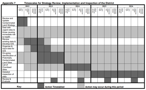
Appendix 8
| Key Guidance for Site InvestigationsKey Guidance for Site Investigations | |
|---|---|
| Publication | |
| General Good Practice |
DEFRA Environmental Protection Act 1990 Model Procedures for the Management of BS 10175:2001 Code of Practice for the Investigation CIRIA Special Publication 103, Site Investigations and Assessment (1995) Guidance for the Safe Development of Housing on |
| Desk Studies |
Documentary Research on Industrial Sites, DETR, 1994, (CLR3) Prioritisation and Categorisation Procedure for Sites which may be contaminated, DETR, 1995 (CLR6) |
| Site Reconnaissance | Guidance on Preliminary Site Inspection of Contaminated Land, DETR, 1994 (CLR2) |
| Intrusive Site Investigations |
Sampling Strategies for Contaminated Land, DETR, 1994 (CLR4) A Framework for Assessing the Impact of Contaminated Land on Groundwater and Surface Water, DETR, 1994 (CLR1) Development of Appropriate Soil Sampling Strategies for Land Contamination, Environment Agency R&D Report HOCO 352 |
Appendix 9
Figure 1 - The Process of managing land contamination.
Source: Model Procedures for the Management of Land Contamination CLR 11.
Last Updated on Friday, January 9, 2026